Climate Change and Rapidly Intensifying Hurricanes
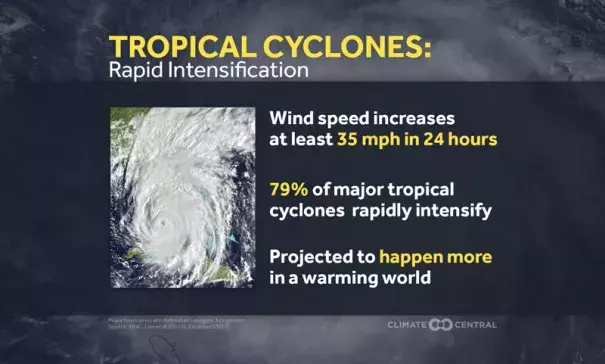
Atlantic hurricane season starts June 1, and last year’s season was devastating for the U.S. Damage from Hurricanes Harvey, Irma, and Maria cost the U.S. $267 billion. All three hurricanes went through a rapid intensification (RI) cycle, meaning the strongest winds within the storm increased by at least 30 knots (about 35 mph) in 24 hours. Harvey jumped from a Category 2 to a Category 4 just before its first landfall. Maria’s intensification was more dramatic, going from a Category 1 to a Category 5. This type of intensification is common in major hurricanes, as 79 percent of major tropical cyclones globally go through at least one cycle of rapid intensification.
We consulted with Phil Klotzbach of the Colorado State Tropical Meteorology Project to examine the historic number of Atlantic named storms that have undergone rapid intensification and to acknowledge limitations in detection. As a result, we are using two starting points for this week’s analysis. The first is 1950, a few years after reconnaissance aircraft analyses began. The second is 1980, a year after regular satellite analyses were available. These data show the active period of the 1950s and 1960s, then a lull, followed by a bigger spike, with the influence of the Atlantic Multidecadal Oscillation (AMO) driving the lower values in the 1970s and 1980s. In a further analysis, one study earlier this year found an increase in rapid intensification from 1986-2015 tied to warming water east of the Caribbean Sea. While the study suggests the AMO is the primary influence, there has also been a net ocean warming on top of that cycle.
As the world continues to warm from the increase in greenhouse gases, the coming decades are likely to bring hurricanes that intensify even more rapidly. In an extreme example from today’s climate, one study indicated that 60 knots (70 mph) of intensification in 24 hours only happens about once a century. With no change in the rate of greenhouse gas emissions, that same extreme intensification rate could happen once every five to 10 years by 2100.
Rapid intensification, especially in the last 24 hours before landfall, leaves people less time to prepare for a hurricane’s impacts. And even people who know a storm is coming may not be ready for how much more intense the storm is when it arrives. For example, less than 24 hours before landfall in Dominica, Maria was forecast to hit the island as a low end Category 3 storm, and it actually made landfall as a Category 5.
Related Content