Headline
Harvey Buffets Windward Islands En Route to Caribbean
Barbados
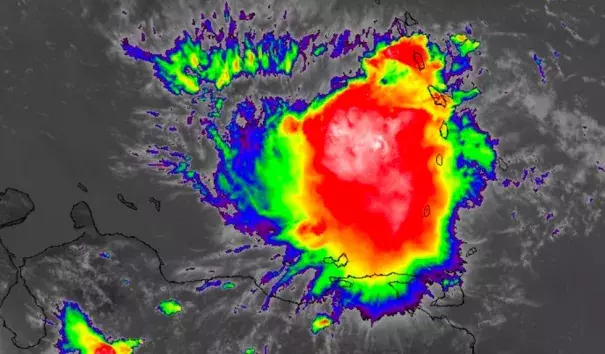
Infrared GOES-16 satellite image of Tropical Storm Harvey as of 1700Z (1 pm EDT) Friday, August 18, 2017. GOES-16 data are preliminary and non-operational. Image: NASA/MSFC Earth Science Branch
Even as a minimal tropical storm (top sustained winds of 40 mph), Tropical Storm Harvey rocked parts of the Windward Islands with high surf, gusty winds, heavy rain, and flooding. As of 11 am EDT Friday, Harvey was located about 15 miles south-southwest of St. Vincent and about 50 miles south-southwest of St. Lucia. Both of those islands experienced the stronger northwest side of the storm. Harvey’s center also passed just south of Barbados, where flooding has been reported, including in the Speightstown area of northern Barbados.
...
Given Harvey’s minimal strength, it’s not surprising that winds have been on the mild side. Here are some peak winds from the passage of Harvey through the Windward Islands on Friday morning:
- Martinique: sustained winds of 29 mph, gusting to 44 mph, at 10 AST
- St. Lucia: sustained winds of 23 mph, gusting to 43 mph, at 9:18 AST
- Barbados: 24 mph sustained winds at 8 am AST
Related Content
Headline
Jun 6, 2018 | LA Times
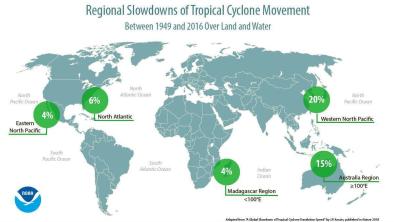
Hurricanes and typhoons are slowing down, which means more time to do damage
Headline
Jun 6, 2018 | KPRC
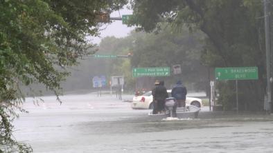
Report gives new insight into just how bad Hurricane Harvey was
Science Source
| Nature
A global slowdown of tropical-cyclone translation speed
James P. Kossin
Headline
May 24, 2018 | The Weather Channel
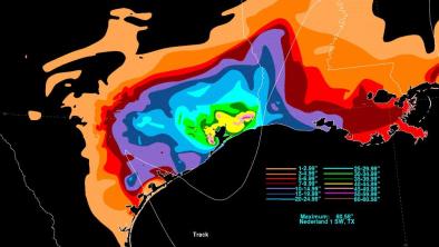
New NOAA Maps Show the Torrents Harvey Unleashed on Texas
