Headline
Here’s What to Know About Harvey’s Storm Surge and Widespread Flood Threat
United States
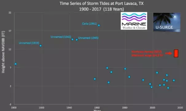
Time series of storm tide (surge plus tide) levels at Port Lavaca above mean sea level from 1900-2017. Hurricane Harvey likely generated a storm tide of 10-12 feet near Port Lavaca, although the highest observed level reported was 7 feet above mean sea level. Photo: Hal Needham
Hurricane Harvey made landfall near Rockport, Texas, as a Category 4 hurricane yesterday evening. This blog post provides some insights on Harvey's storm surge and widespread flood threat.
Highest Surge
Harvey's highest storm surge occurred east of Rockport.
...
A NOAA Tides and Currents gauge at Port Lavaca, Texas, reported an observed storm tide level of 7.0 feet above Mean Sea Level (MSL) at 3:48AM Central Time. Unreported storm tides in this region likely reached as high as reached 10-12 feet.
Port Lavaca
Harvey has generated the highest storm surge at Port Lavaca since Hurricane Carla (1961).
Related Content
Headline
Jun 6, 2018 | LA Times
Hurricanes and typhoons are slowing down, which means more time to do damage
Headline
Jun 6, 2018 | KPRC
Report gives new insight into just how bad Hurricane Harvey was
Science Source
| Nature
A global slowdown of tropical-cyclone translation speed
James P. Kossin
Headline
May 24, 2018 | The Weather Channel
New NOAA Maps Show the Torrents Harvey Unleashed on Texas
