June 2016 ENSO discussion: The new neutral
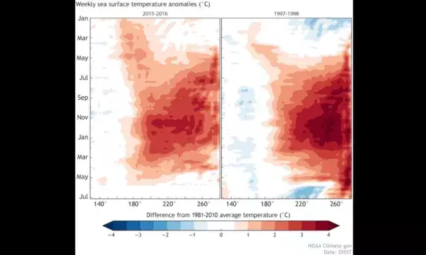
We’re sticking a fork in this El Niño and calling it done. After spending more than a year above average, sea surface temperatures in the central and eastern equatorial Pacific had mostly returned to near average by the end of May. Forecasters don’t think we’ll remain in neutral territory for long, though. There’s an approximately 65% chance that sea surface temperatures will drop into the La Niña realm (more than 0.5 degrees below normal) by the July – September period. This chance increases to around 75% by the fall.
I’ll get into what’s behind these numbers in a bit, but first, let’s bid a fond farewell to the big 2015-2016 El Niño.
The king is dead!
As we’ve reiterated many times in this blog, the El Niño/La Niña (ENSO) cycle is characterized by the changes in tropical Pacific temperatures and the corresponding response of the atmosphere. During El Niño, atmospheric changes include weaker trade winds and upper-level winds, more convection and rainfall in the central or eastern Pacific, and drier conditions over the far western Pacific and Indonesia. Over the past few months, the tropical Pacific has cooled off rapidly, and all these atmospheric indicators returned to average conditions during May.
Related Content