Photos of 'king tides' globally show risks of climate change
Signals Summary: Climate change is greatly accelerating sea level rise by causing glacier and ice sheets to melt and the ocean to expand. This leads to higher tides, including king tides, and more coastal flooding.
Article Excerpt: Tourists, nature lovers and amateur scientists are whipping out their cameras to document the effects of extreme high tides on shorelines from the United States to New Zealand, and by doing so are helping better predict what rising sea levels will mean for coastal communities around the world.
...
“For us, the king tide offers a look at where the water will be in about 2050, about a foot to a foot and half (30 to 46 centimeters) above normal water levels,” said Skip Stiles, executive director of Wetlands Watch, a nonprofit that helped recruit 700 people to document a king tide in Norfolk, Virginia, for the first time there in 2017.
...
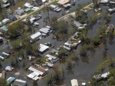
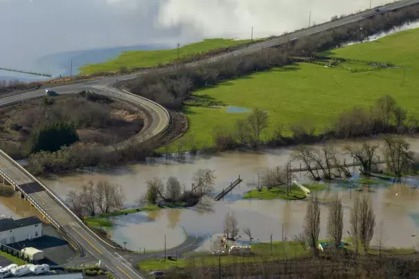
King tides occur about twice a year in coastal areas worldwide when the sun and moon align to enhance the gravitational pull that produces normal, daily tides. These super-high tides came into sharp focus in January, when one arrived in Oregon on the same day as a major winter storm, creating 15- to 20-foot (4.6- to 6.1-meter) waves and a massive swell that sucked a man and his two young children out to sea. The woman who called 911 had been photographing the tides from her yard for the Oregon King Tides Project. The children, ages 4 and 7, died.
...
Flooding from king tides is a preview of how sea level rise will affect coastal communities — and warmer oceans and bigger storms could amplify those changes, said Peter Ruggiero, interim executive director of the Oregon Climate Change Research Institute. Modeling shows Oregon could experience sea level rise of as little as a foot (30 centimeters) or as great as 6 feet (1.8 meters) in a worst-case scenario, he said.
Some of these King Tide Projects, like the one in Oregon, are run by nonprofit groups, while others are in partnership with state and local governments. They all have the same goal: to educate the public and provide a clear-eyed assessment of how climate change will affect everyday life, from flooded intersections to cows grazing in knee-high salt water, to popular beaches swallowed by waves.
“A lot of the conversation around climate change was what was happening far away and not about what people were going to be experiencing in their own lives,” said Marina Psaros, who helped develop California’s King Tides Project. “The goal of the project was to get people thinking more about climate change locally instead of just polar bears.”
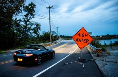
In Georgia, coastal communities constantly struggle with flooding from high tides and storms — a phenomenon dubbed “sunny day flooding” in places across the U.S. South. Chatham County, home to the low-lying city of Savannah, uses dozens of sea level sensors to track tides and collect data for future city planning. It has also begun asking people to snap pictures during flooding.
Related Content