The Record-Long Mississippi River Flood of 2019 Is Finally Ending, But One Big Concern Remains

The longest Mississippi River flood on record is finally coming to an end, as several locations in flood for months have dropped, or will finally drop, below flood stage in the coming days in Louisiana, Mississippi, Missouri and Illinois.
In Vicksburg, Mississippi, the river dropped below flood stage over the weekend for the first time since mid-February.
Similarly, in Greenville, Mississippi, the five-month-plus stretch in flood stage ended on July 21, snapping a record streak set by the Great Flood of 1927. It is forecast to drop below flood stage in Natchez, Mississippi, by this weekend.
Downstream in Louisiana, it's been a year-long flood fight.
At Red River Landing in Pointe Coupee Parish, about 45 miles northwest of Baton Rouge, the Mississippi River is forecast to drop below flood stage by the second week of August for the first time this year.
It has been above flood stage at Red River Landing for a record 214 straight days through July 29, since first rising into flood on Dec. 28, 2018. This smashed the previous record-long flood of 1927 by a full two months, according to the National Weather Service office in Slidell, Louisiana.
It's also been a record wait in Baton Rouge, with 205 straight days above flood stage through July 29. The river is forecast to finally dip below flood stage in early August.
...
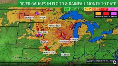
The first six months of 2019 were among the 10 wettest January-through-June periods on record in much of the Mississippi Valley, Plains, Ohio Valley and Great Lakes, according to NOAA. It was the wettest such first half of any year in Illinois.
...
this flood saga resulted from multiple heavy rain events running virtually back-to-back that didn't allow the mainstem Mississippi River to recover.
Some of these heavy rain events included:
-February: Record rain in parts of the Tennessee Valley, heavy rain into the mid-Mississippi and Ohio valleys and record snow in the upper Mississippi Valley, which would later melt.
-March: "Bomb Cyclone" led to record flooding from heavy rain that melted snow and triggered ice jams.
-April: Soaking rain targeted primarily the lower Mississippi Valley, though spring snowstorms blanketed parts of the northern Plains and upper Midwest with late-season snow.
-May: Multiple rounds of heavy rain from Texas to the northern High Plains led to record flooding along the Arkansas River and its tributaries in Arkansas and Oklahoma.
-June: Locally heavy rain persisted in parts of the Ohio Valley and lower Mississippi Valley.
-July: Hurricane Barry dumped torrential rain in the lower Mississippi Valley, including a potential state record for tropical cyclone rainfall in Arkansas. Barry also led to a temporary rise on the Mississippi River at New Orleans from storm surge.
Each of these rounds of heavy rain sent a volume of water from smaller rivers and streams to larger tributaries, then to the mainstem Mississippi River.
Related Content