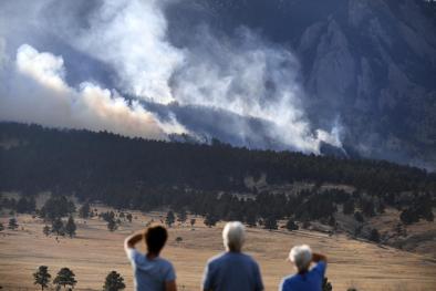
Stormy pattern eyes central and southern U.S. with potential flooding and severe thunderstorms
Climate Signals Summary: Climate change is increasing extreme rainfall events, and in some regions the total amount of rain, which greatly increases the risk of flooding.
Article Excerpt: Strong to severe thunderstorms are possible from the Plains to the Southeast this week as an active stretch of stormy weather takes hold across the Lower 48 states. Gusty winds, hail and isolated tornadoes will be possible in the strongest thunderstorms.
While a large-scale, significant tornado outbreak is not anticipated, the stage is set for multiple rounds of thunderstorms.
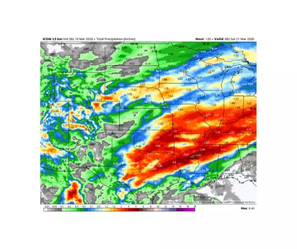
Meanwhile, an equally noteworthy risk exists for flooding, particularly from the Interstate 35 corridor in Texas and Oklahoma through the Ozark Plateau, eventually stretching up through the Mississippi, Tennessee and Ohio valleys. Parts of the Mississippi River are under flood warnings, with heavy downpours on the way later this week.
“The main story during the medium-range period will be the continual threat of heavy rain across the central portion of the country,” wrote the Weather Prediction Center, part of the National Weather Service.
The mischievous weather comes during the climatological ramp-up of both the severe weather and spring flood seasons. For many, it’s a reminder of what’s likely to be on the way for April and May as the changing seasons battle it out.
...
Regardless of how intense the thunderstorms become, there is a risk of flooding where heavy rain repeatedly moves over the same areas. This could become problematic by Wednesday afternoon over the Southern Plains, somewhere between the Dallas-Fort Worth metroplex and the Red River, along the Oklahoma border.
Different models place the bull's eye of two to three inches of rain in slightly different locations, but there is a risk of excessive rainfall in Dallas, Fort Worth and perhaps Wichita Falls.
Farther south, models are highlighting San Antonio as a secondary location that could see heavy rainfall in the Wednesday-Thursday time frame.
Late on Thursday, the risk of heavy rain expands to Arkansas, the Ozarks, and perhaps parts of the Tennessee and Ohio valleys.
“One to two inches of rain will accompany the front, and there could be locally more. This may lead to flash flooding in places,” wrote the National Weather Service in Little Rock.
...
The South and Southeast have had an early start to their spring flood season, with a number of flood warnings posted along the already-swollen Mississippi River and tributaries. In February, the Pearl River at Jackson, Miss., crested at its third-highest level on record, inundating parts of the state capital.
Alabama also struggled with copious rainfall during February, sparking worries at area dams and shuttering schools in Birmingham. Water rescues were needed in Tuscaloosa on Feb. 10.
Unfortunately, it looks as though heavy rain and flood concerns are likely to persist into late March. The National Weather Service in Memphis wrote that “the unsettled spring pattern appears likely to continue next week.”
Related Content