Headline
Tropical Storm Harvey Forms; Warnings for Windward Islands
Atlantic Ocean
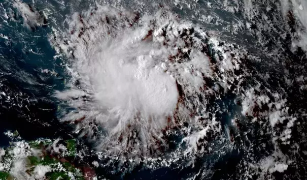
Visible-wavelength GOES-16 satellite image of Potential Tropical Cyclone 9 before it became Harvey, taken at 1515Z (11:15 am EDT) Thursday, August 17, 2017. GOES-16 data are preliminary and non-operational. The RAMMB site also has a "floater" loop zoomed in on Harvey, but this will be dark at night. Photo: RAMMB / CIRA@CSU
The Atlantic’s eighth named storm of 2017, Tropical Storm Harvey, is en route to the Caribbean. Air Force Hurricane Hunters found that Harvey had gained a closed low-level circulation, with peak winds of around 40 mph, so the former Potential Tropical Cyclone 9 was upgraded to TS Harvey by the NOAA/NWS National Hurricane Center in its 5:00 pm EDT Thursday, [August 17] advisory. During the years 1966-2009, the average arrival date of the eighth storm of the Atlantic season was September 24—more than a month later than this year’s formation of Harvey—so 2017 is considerably more active than usual.
Related Content
Headline
Jun 6, 2018 | LA Times
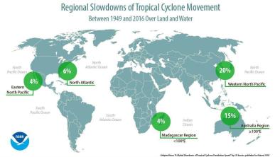
Hurricanes and typhoons are slowing down, which means more time to do damage
Headline
Jun 6, 2018 | KPRC
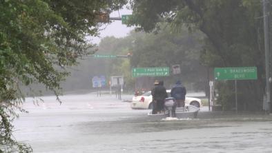
Report gives new insight into just how bad Hurricane Harvey was
Science Source
| Nature
A global slowdown of tropical-cyclone translation speed
James P. Kossin
Headline
May 24, 2018 | The Weather Channel
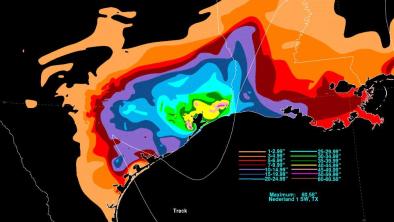
New NOAA Maps Show the Torrents Harvey Unleashed on Texas
