Worst case scenario looms for Texas with Hurricane Harvey
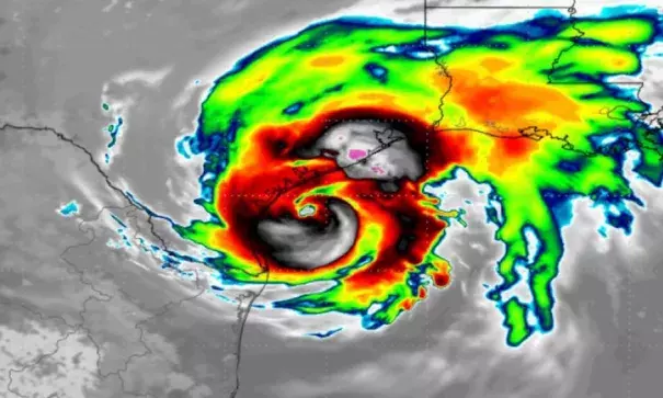
Hurricane Harvey is rapidly intensifying over the bathtub-warm waters of the Gulf of Mexico, rocketing from a tropical depression to an 85-mile-per-hour hurricane in less than 24 hours, with more intensification to come.
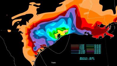
The storm is forecast to roar ashore along the middle Texas coast with maximum sustained winds of 125 miles per hour, making it a high end Category 3 storm, on Friday night or Saturday morning.
The storm presents south and southeastern Texas with nothing short of a worst-case scenario.
It's as if a meteorologist were asked to conjure up a storm that would challenge citizens and emergency managers to the maximum degree, and then accidentally unleashed that storm into the real world.
...
“Any time you have a Category 3 storm, it is a threat. Now add in the fact that it may sit in some form for almost a weak dumping rain, you have a huge problem,” said Marshall Shepherd, a professor of meteorology at the University of Georgia, in an email.
Shepherd tweeted on Thursday morning that he feared an “epic flood catastrophe” from Harvey.
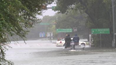
Such a scenario, with a juiced up hurricane making landfall and stalling out, is the stuff of nightmares for flood forecasters, since the number one killer from tropical cyclones is inland flooding. Though most people think of wind as a hurricane's greatest weapon, flooding kills nine out of 10 people who perish in such storms.
...
Because the storm will hit the coast and then stall, storm surge flooding could occur during multiple high tide cycles, subjecting the coast to battering waves that will exacerbate the damage.
Related Content