Hurricane Harvey: Why Is It So Extreme?
Why did Hurricane Harvey so quickly explode from a Category 1 hurricane to Category 4?
Last Wednesday night, August 23, Harvey was a tropical depression, but after just eight overnight hours it was forming a hurricane eye wall. “That’s remarkably fast,” Masters says. On Friday it rapidly ballooned from a Category 1 hurricane to Category 4. That is because it happened to pass over a region of extremely warm ocean water called an eddy. This spot of hot water was 1 to 2 degrees Fahrenheit warmer than the Gulf of Mexico around it, which itself was already 1 to 2 degrees F higher than average, reaching 85 or 86 degrees F in places. The hotter the water, the more energy it drives into a storm. Hurricane Katrina, which destroyed New Orleans in 2005, also mushroomed to Category 4 in a similar fashion because it, too, passed over a hot eddy in the Gulf.
...
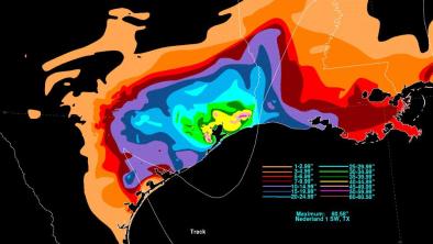
How can Harvey produce such extreme rainfall even though it is no longer over the ocean?
The answer to this is fascinating. Normally a hurricane pulls moisture up from the ocean and releases it as rain all around the storm’s area, particularly in the northeastern quadrant. But Harvey has dropped so much water over such a large area of southeastern Texas that the storm is pulling that water back up into itself and dumping it again as more rain. The flood area is so far and wide that it is acting like part of an ocean, feeding warm moisture up into Harvey. “You only need about 50 percent of the land to be covered with water for that to happen,” Masters says. “Obviously we have more than that in Texas.”
...
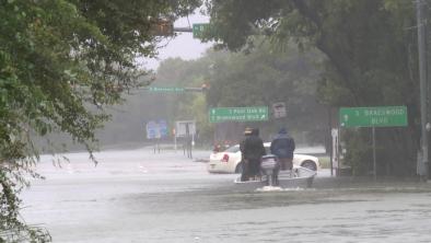
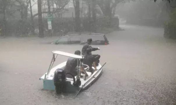
Why has Harvey caused such deep coastal flooding even though the ocean storm surge was not so high?
This answer is also intriguing. Storm surge is often the deadliest aspect of tropical systems. Hurricane Katrina’s storm surge drowned New Orleans. Hurricane Sandy’s surge inundated New York City and New Jersey. Harvey’s storm surge was not nearly as high, yet water piled up along certain portions of the Texas coast. Masters says this is called “compound flooding.” With feet of rain, the rivers are so swollen that they are rushing toward the Gulf coast, but the storm surge is coming inland as those rivers try to flow seaward. The two surges meet at the coast “and the water piles up from both sides,” Masters says. The land’s shape and elevation at any location can make the compound flooding worse. In Galveston, for example, the sea surge was about three feet but the actual water surge was about nine feet.
Related Content