Rosa Hitting SW U.S., Baja With Heavy Rains; Updates on Leslie, Kong-Rey, Trami, and Walaka
Flash flood watches are posted for most of Arizona, Utah, southeast Nevada, and southeast California through Tuesday night as moisture from Tropical Storm Rosa sweeps inland. Rosa was weakening quickly on Monday afternoon due to high wind shear and cool waters as it steamed north-northeastwards at 12 mph towards the northern portion of Mexico’s Baja Peninsula. The center is likely to cross the coast of northern Baja late Monday afternoon.
...
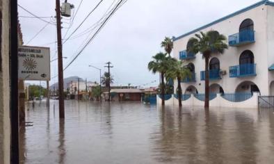
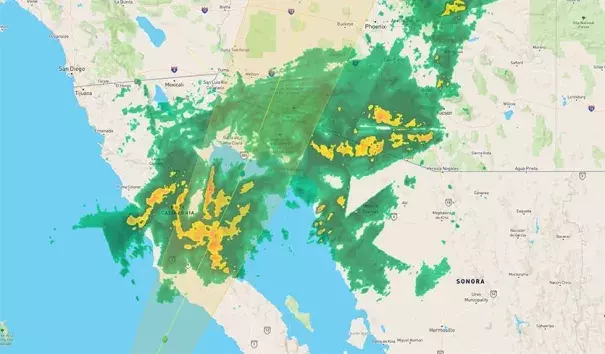
Rosa was already spreading a large area of heavy rain inland on Monday morning, triggering a flash flood warning in southern Arizona near Bosque. Radar-estimated rainfall rates of 2 – 3 inches per hour were occurring in Rosa’s strongest thunderstorms near the Mexico/Arizona border, as seen on the Yuma, AZ radar. As of 9 am MDT, Ajo, AZhad recorded a 24-hour rainfall amount of 2.29”.
...
An unusually northerly landfall
Rosa will make landfall at an unusually far north location on Mexico’s Baja Peninsula: near 29.5°N latitude, or about 200 miles south-southeast of San Diego. Since accurate record keeping began in 1949, just three tropical storms have made landfall along the west coast of the Baja Peninsula at a more northerly latitude than that: Tropical Storm Kathleen of 1976, Tropical Storm Jen-Kath in 1963, and an unnamed storm in 1951. Unusually warm sea surface temperatures (SSTs), about 1 – 2°C (1.8 – 3.6°F) above average, will help allow Rosa to maintain tropical storm strength to such a northerly latitude.
...
Southwest U.S. hurricane history
Southern Arizona experiences flash flooding directly or indirectly associated with a tropical cyclone about once every two years, and a tropical depression or tropical storm moves across southern Arizona about once every five years, according to the National Weather Service in Tucson. Four of the five most serious floods in southern Arizona since 1970 were caused by tropical cyclones.
Related Content