The Central U.S. Is About to Get Hit With a Bomb Cyclone
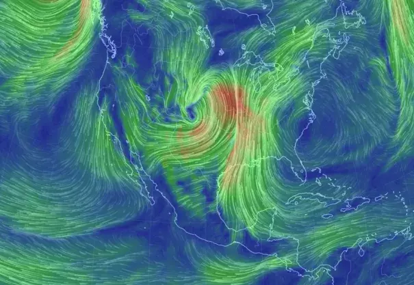
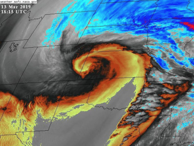
As the storm pushes inland, its pressure—which drops as storms get stronger—is expected to dip into the range of 970 millibars. That’s roughly on par with an average Category 2 Atlantic hurricane and could challenge the all-time low pressure record for Kansas. The drop will be driven by the storm’s winds as they wrap around its core in a counter clockwise direction, bringing moist, warm air from the Gulf of Mexico in contact with cold air from the Upper Midwest and Canada. The movement of the winds is called cyclonic, and pressure is expected to drop more than 24 millibars in 24 hours, which means this storm is shaping up to fulfill the criteria for a rare inland bomb cyclone. It could even take on a hurricane-like appearance.
...
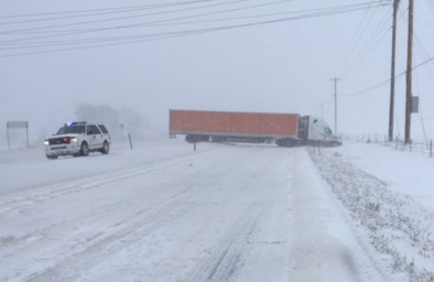
The area facing wind gusts up to 60 mph—the equivalent of a mature tropical storm—stretches for more than 1,000 miles from Sturgis, South Dakota to the Texas-Mexico border. For comparison, the reach of Sandy’s tropical storm-force winds was 1,150 miles from edge to edge, although even that’s not a perfect comparison, since tropical storm winds start at 39 mph.
So about those winds. The most intense blasts could rip up to 75 mph in the Rockies and Southern Plains. The rotation of the storm will also create what Furtado called “a moisture pipeline straight out of the Gulf of Mexico.” That means not only will it be windy, but also snowy. The National Weather Service is forecasting up to a foot or more of snow from Colorado to the Dakotas. Blizzard warnings are also in effect for large part of the region, and they could expand as the storm begins its onslaught.
Related Content