Centuries of intense surface melt on Larsen C Ice Shelf
[Note: as of June 28, 2017, the Journal Cryosphere reports this paper was received on May 3, 2017 and accepted for review on May 20, 2017. Public discussion started on May 30, 2017 and is open for public comment until July 27, 2017]
Following a southward progression of ice-shelf disintegration along the Antarctic Peninsula, Larsen C Ice Shelf is the focus of ongoing investigation regarding its future stability. The ice shelf is known to be experience surface melt, and commonly features surface meltwater ponds. Here, we use a flowline model and a firn density model to date and interpret observations of melt-affected ice layers found within five 90 m boreholes distributed across the ice shelf. We find that units of ice within the boreholes, which have densities exceeding those expected under normal compaction metamorphism, correspond to two climatic warm periods within the last 300 years on the Antarctic Peninsula. The more recent warm period, from the 1960s onwards, has generated distinct sections of dense ice in two boreholes in Cabinet Inlet, close to the Antarctic Peninsula mountains—a region currently affected by föhn winds. Previous work has classified these layers as refrozen pond ice, requiring large quantities of mobile liquid water to form. Our flowline model shows that, whilst preconditioning of the ice began in the late 1960s, it was probably not until the early 1990s that twentieth-century ponding began. The earlier warm period occurred during the 18th century and resulted in two additional sections of anomalously dense ice deep within the boreholes. The first, in one of the Cabinet Inlet boreholes, consists of ice characteristic of refrozen ponds and must have formed in an area currently featuring ponding. The second, in a mid-shelf borehole, formed at the same time in an area which now experiences significant annual melt. Further south on the shelf, the boreholes sample ice that is of an equivalent age but which does not exhibit the same degree of melt influence. This west–east and north–south gradient in past melt distribution resembles current spatial patterns of surface melt intensity. Using flowlines to trace the advection and submergence of continental ice identified in boreholes, we demonstrate that, even by the time the ice reaches the calving front, only the upper 40 to 50% of the shelf is composed of meteoric ice accumulated on the shelf. This vertical composition implies that basal crevasses must be confined within continental and/or basally accreted ice, and therefore will be unaffected by current climate-induced firn compaction.
…
Recent trends in surface melt parameters on the Antarctic Peninsula, such as onset date and duration or intensity, depend on the time period under consideration. During the second half of the 20th century, mean annual temperatures were increasing and melt trends, based on sums of positive degree days (PDDs) from the few meteorological stations with measurements during this period, showed increases significant at the 95% confidence level or better. When analyses include the first decade of the 21st century, during which time AP mean annual temperatures decreased, the trends based on PDDs remained positive but less steep (Barrand et al., 2013). The various studies do however reveal a large amount of interannual variability, with annual meltwater volume varying by a factor of 4 during the period 1979 to 2010 (Kuipers Munneke et al., 2012).
…
From boreholes imaged along the Cabinet Inlet flowline we can deduce that warming from the mid 20th century preconditioned the surface of the ice shelf within the inlet, until it became sufficiently impermeable to support surface ponds. The earliest possible date for 20th century pond formation, based on the 15.64 m base of U3 at CI-22, is the late 1960s. This date coincides with a switch to increasing positive SAM indices, a strengthening of the circumpolar vortex, and more frequent föhn events. Firn density modelling starting from 1979 indicates that the surface was able to support ponds by 1993 and satellite observations confirm that ponds were present by the late 1990s.
Intense melt on the northern part of LCIS, and probably ponding within Cabinet Inlet, also occurred during the 18th century corresponding with an earlier period of warming over the AP. Unit 3 ice, at the base of the CI-22 borehole was forming up until 200 years BP, and U2 5 at the base of the CI-120 borehole up until about 280 years BP.Whilst U3 probably reflects the influence of föhn winds, U2 indicates more widespread warming over the shelf.
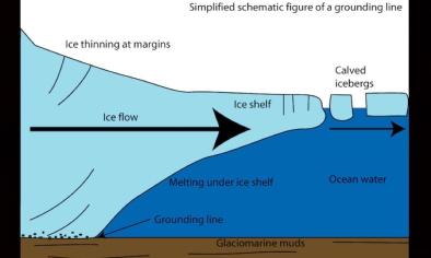
… we estimate that even by the shelf edge, where the proportion of shelf ice consisting of meteoric ice is at a maximum, only the upper 40 or 50% consists of local accumulation. Below this depth the shelf ice must consist either of continental ice or accreted marine ice. This vertical heterogeneity has implications for determining the resistance of the shelf to rifting and calving, it being the meteoric ice that exhibits the least resistance to rifting (McGrath et al., 2014). Basal crevasses are observed to penetrate upward through only the lower 200 m of shelf ice and therefore will be restricted to continental or basal accreted ice and not be affected by atmospheric processes acting on the firn. This research demonstrates that the current setting of LCIS, featuring extensive, and in places intense, surface melt, and located immediately south of the boundary of AP ice-shelf viability, is not without precedence in the last 300 years. The previous AP warm period in the 18th century is captured in the stratigraphy of the shelf and is further evidence of the link between atmospheric warming and the collapse or decay of eastern AP ice shelves throughout the Holocene.
Related Content


