California Floods January 2017
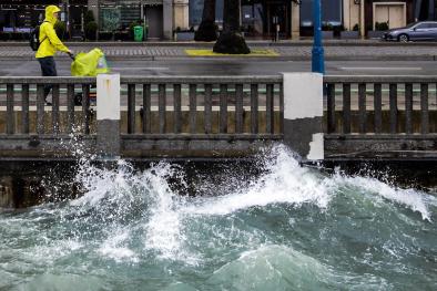
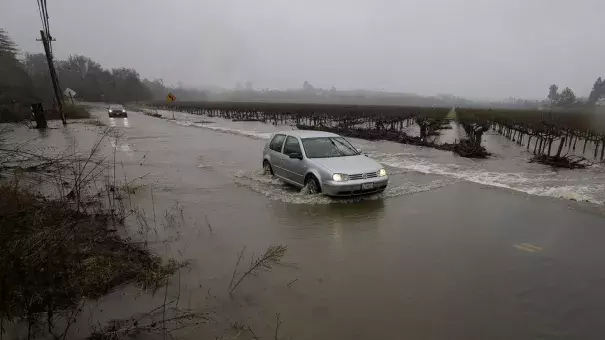
On January 3 and 4, the first of two back-to-back atmospheric river storms brought heavy rain, mountain snow, and localized flooding to central California. The second storm, fueled by a powerful, long-duration atmospheric river funneling warm and moist air from southeast of Hawaii, hit central and northern California beginning late on January 7 and pushed major rivers past flood stage levels and drove extreme gusts, leading to power outages as well as rock and mudslides. Temperatures during the second storm were warm, which pushed snow levels back above the Sierra passes and converted snowfall to rainfall, elevating flood risk. A 3rd storm dropped additional heavy rain and snowfall amounts up to 4 inches on January 10 and up to 6 inches on January 11. These storms are consistent with observed trends and projections indicating that extreme precipitation in California, as well as globally, increases generally in a warming climate. Moreover, projections indicate that the most intense atmospheric river storms in particular increase in California in a warming climate. In addition, warmer temperatures means more precipitation falls as rain rather than snow, elevating the risk of flooding. Snow levels retreat to higher elevations, diminishing snow pack and increasing runoff and flooding risk.
Climate connections at-a-glance
- A warmer atmosphere drives more extreme precipitation across all storm types, which in turn increases the the risk of flooding.
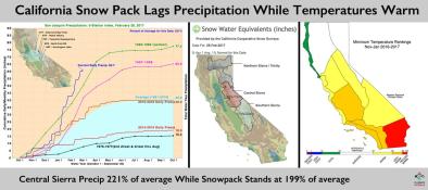
- Warming temperatures convert snowfall to rainfall, which in turn can melt snow pack. Both factors increase the risk of flooding. In California warming temperatures for the first time recently exceeded the key threshold for maintaining snow pack.
- Atmospheric river storms are projected to increase in intensity and duration in California in a warming climate, with the most intense atmospheric river storms becoming more frequent.
- Overall conditions in California become more polarized in a warming climate, shifting toward both more drought and more flood, often alternating.
One-two punch of atmospheric river storms brings extreme precipitation and flooding to central California
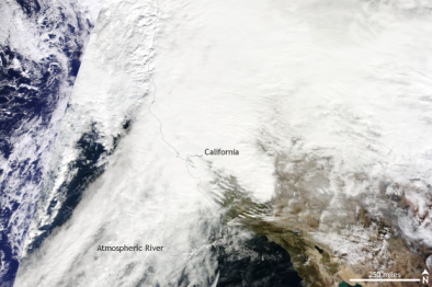
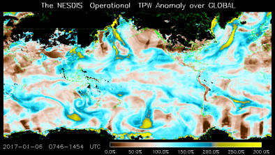
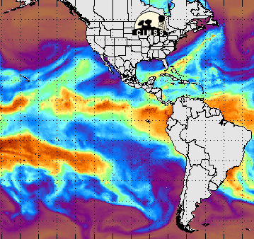
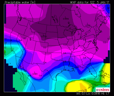
On January 3 and 4, the first of two back-to-back atmospheric river storms (wide paths of moisture in the atmosphere composed of condensed water vapor), brought heavy rain and mountain snow to central California, ahead of an even more intense round of heavy precipitation brought by a powerful, long-duration atmospheric river storm pulling warm and moist air to California from the subtropical and equatorial region southeast of Hawaii.
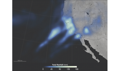
By 4am Pacific Time on January 4, central California experienced widespread 24-hour rainfall amounts of 3 to 5 inches, and some 5 to 7 inch totals.[1] Anderson Peak in Monterey County received 7.25 inches in 24-hours.[1] Three Peaks, also in Monterey County, received 12.6 inches in the 48-hour period ending at midnight on January 4.[2]
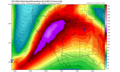
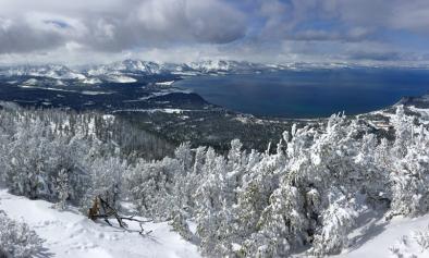
The second atmospheric river storm hit late on January 7, causing a prolonged period of heavy rainfall. This system was drastically warmer than its predecessor, pushing snow levels to retreat above the majority of the recently-fallen snow pack.[3] In South Lake Tahoe (elevation 6200’), temperatures were warmer than in Houston.[4]
In the high elevation peaks of Alpine Meadow, wind gusts of up to 174 mph were recorded,[5] while Squaw Valley saw gusts up to 159 mph.[6]
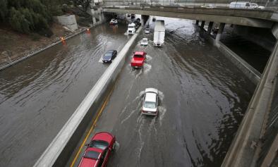
Several locations along the Sacramento, Russian, Napa, Cosumnes, Truckee, and Merced Rivers were forecast to surpass flood stage on the night of January 8.
The storms and resulting floods are consistent with research indicating that the climate change is changing precipitation and flooding risk in California.
Climate change increases the risk of extreme precipitation and flooding
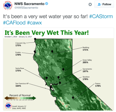
There has been an increase in the intensity and frequency of extreme precipitation events across the United States.[7] In the Southwest region, where the increase is the smallest do date, the amount of precipitation falling in very heavy events (defined as the heaviest 1 percent of all daily events) increased by 5 percent from 1958 to 2012.[8] In Sacramento, historical analysis reveals a trend toward less light rainfall and more moderate and heavy rainfall in the second half of the 20th century.[9] The change in intensity is mostly focused in Northern California, though some Southern California stations such as Los Angeles show similar changes.[9]
In California, climate conditions are polarizing further toward the flood/drought pattern that has repeatedly visited the state over the last century.[10] Overall basin dryness has increased, due to warming temperatures which dry out soils. This in turn decreases flood risk.[11] However as rainfall is concentrated into extreme precipitation flood risk increases. [7]
Warming is linked to increases in precipitation extremes partly because of the physical effect of warming on atmospheric conditions. Warmer air can hold more moisture (for each 1°C of warming, saturated air contains 7 percent more water vapor).[12] Air laden with more moisture can drop more extreme rain and snowfall and provides greater latent energy to drive storms.[13]
Recent work has revealed a critical role for atmospheric rivers (ARs) in driving extreme precipitation events.[14][15][16][17] In California, ARs deliver up to one-half of the state's entire annual precipitation over the course of only 10 to 15 days.[18] Between 1996 and 2007, all seven declared floods on California's Russian River were linked to atmospheric rivers.[16] A longer term analysis showed that of 39 declared floods on the Russian River since 1948, 87 percent were caused by atmospheric rivers.[19]
Warmer temperatures mean more precipitation falls as rain than snow, increasing flood risk
Warmer conditions cause more precipitation to fall as rain instead of snow, which increases the risk of severe floods. This effect can be compounded when relatively warm rains fall on and melt existing snow pack.[20]
The winter of 2014 set a new seasonal record at 4.4°F (2.4°C) above the 20th century average, until 2015 bested that record by 1.5°F (0.83°C), or 5.9°F (3.3°C) above average. The winter average minimum temperature of 2014-15 for the Sierra Nevada region was 32.1°F, the first time this value was above water’s freezing point in 120 years of recordkeeping.[21]
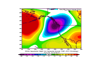
Models project that climate change will increase the intensity and duration of atmospheric rivers impacting California
Climate models project that the intensity and duration of atmospheric rivers increase in the Golden State in a warming climate, with the most intense atmospheric river storms becoming more frequent. In addition, the AR season is prolonged and landfall locations change. In looking at recent observations, a detectable signal has not yet arisen out of the background noise made up by natural variability to confirm that climate change is already affecting the frequency of atmospheric rivers storms in California. [22][23][24][25]
A July 2015 study finds that climate change may increase horizontal water vapor transport by up to 40 percent in the North Pacific, due mainly to increases in air moisture.[26] Historically, the most intense storms and precipitation events in California have been tied to wintertime atmospheric rivers that fed on high levels of water vapor in the air.[17]
The expected increases in flows of atmospheric moisture into California’s coastal ranges and the Sierra Nevada are projected, in turn, to increase winter flood risk in rivers.[8]
Climate model projections suggest that by year 2100, both intense drought and flooding may increase in frequency by at least 50 percent.[27]
Extreme atmospheric river storms and floods present a clear danger to agriculture. A 2011 report by the US Geological Survey (USGS) found that a single extreme 1000-year atmospheric river winter storm along the US West Coast could cause up to $725 billion in damages to the California economy, much of that from flooding in the Central Valley.[28]
Related Content