Torrential rain hits Southeast as forecast warns of major spring flooding
Climate Signals Summary: Climate change is increasing the frequency of extreme rainfall events because warmer air can hold more moisture.
Article Excerpt: A week of torrential downpours is underway across the Southeast and lower Mississippi Valley. With saturated ground and swollen rivers, the three-month outlook calls for the likelihood of major river flooding this spring in some of the same areas hard hit by last year's historic floods.
The combination of a stalled front, strong Pacific jet stream and near-record atmospheric moisture levels Monday prompted NOAA's Weather Prediction Center to warn of the "high risk" of life-threatening flash flooding.
...
This deluge comes on top of already saturated soil from a unseasonably wet season so far. Since January 1, the Southeast has received 2 to 3 times the normal rainfall, with various areas (in dark green below) receiving their wettest stretch on record.
With spring runoff just around the corner, the season is not off to a promising start. While river flooding is not expected to reach the historic levels of last year, NOAA's new river forecast for February through April calls for another significant flood season ahead for much of the Mississippi and Missouri River basin, especially the north end.
...
The three month outlook from NOAA's Climate Prediction Center calls for above-normal precipitation and below-normal temperatures through April. If correct, that means a further buildup of snow pack combined with frozen ground.
...
In 2019 the Mississippi River experienced its longest flood event on record and the Missouri River recorded its 2nd highest water volume, just short of a 122-year record set in 2011. The flooding contributed to a near-record number of farm bankruptcies and caused an estimated $20 billion in damage.
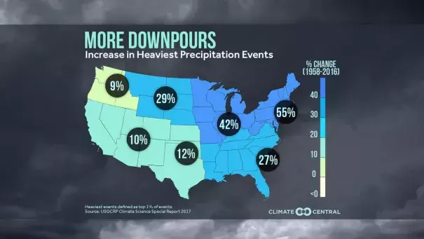
An increase in rain and flooding is consistent with what is expected from a warming climate. Simply put, warmer air holds more water and dumps heavier rain. Since the 1950s there's been a 30% to 40% increase in heavy precipitation events in the Upper Midwest and Northern Plains states.
The trend of increasing heavy rainfall is expected to continue in the decades ahead, especially in the Upper Midwest and Northern Plains, according to last year's National Climate Assessment from the federal government.
