Hurricane Dorian poised to slam the Carolinas after scraping the coasts of Florida and Georgia
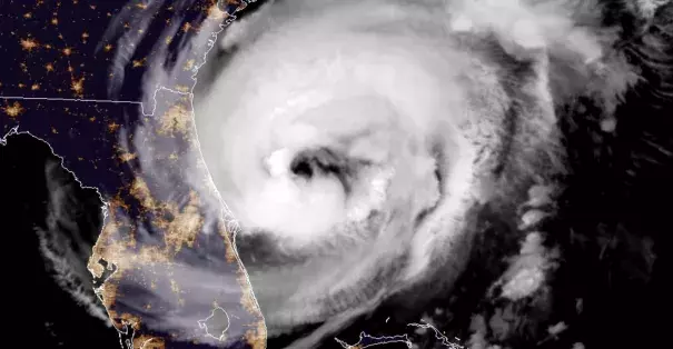
As of 9 a.m. on Wednesday, the storm was 90 miles east-northeast of Daytona Beach, Fla., and moving north-northwest at 8 mph. The storm’s peak sustained winds were 105 mph, making it a high-end Category 2 storm. Dorian is expected to maintain its current intensity through Thursday.
The storm has grown larger since the weekend; hurricane-force winds extend outward up to 60 miles from the center, and tropical-storm-force winds extend outward up to 175 miles.
...
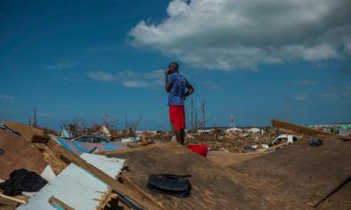
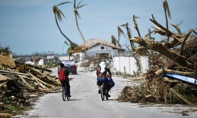
Northwest Bahamas took a nightmarish, 40 hour direct hit
Between late Sunday and Tuesday, Dorian slammed into the northwestern Bahamas with wind gusts up to 220 mph and a 23-foot storm surge. Video and images emerging from the Bahamas show a toll of absolute devastation on Great Abaco and Grand Bahama Islands, two locations where the eye of the storm made landfall.
Grand Bahama Island suffered an onslaught from this storm that few places on Earth have experienced, remaining in the eyewall of a major hurricane (between Category 3 and 5) for 40 hours. The eyewall is the most severe part of a hurricane that contains its strongest winds and generates the most destructive storm-surge flooding.
Dorian came to a virtual standstill as it encountered the northwest Bahamas. Between 3 a.m. on Labor Day and 5 a.m. on Tuesday, the storm moved just 30 miles in 28 hours. In addition to wind gusts up to 220 mph and a 23-foot storm surge, up to 40 inches of rain were estimated in some areas.
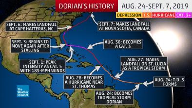
Dorian’s place in history
Dorian is tied for the second-strongest storm (as judged by its maximum sustained winds) ever recorded in the Atlantic Ocean, behind Hurricane Allen of 1980, and, after striking the northern Bahamas, tied with the 1935 Labor Day Hurricane for the title of the strongest Atlantic hurricane at landfall.
It is only the second Category 5 hurricane to make landfall in the Bahamas since 1983, according to Phil Klotzbach of Colorado State University. The only other is Hurricane Andrew in 1992. The international hurricane database goes back continuously only to 1983.
The storm’s peak sustained winds rank as the strongest so far north in the Atlantic Ocean east of Florida on record. Its pressure, which bottomed out at 910 millibars, is significantly lower than Hurricane Andrew’s when it made landfall in South Florida in 1992 (the lower the pressure, the stronger the storm).
With Dorian attaining Category 5 strength, this is the first time since the start of the satellite era (in the 1960s) that Category 5 storms have developed in the tropical Atlantic for four straight years, according to Capital Weather Gang tropical weather expert Brian McNoldy.
The unusual strength of Dorian and the rate at which it developed is consistent with the expectation of more intense hurricanes in a warming world. Some studies have shown increases in hurricane rapid intensification, and modeling studies project an uptick in the frequency of Category 4 and 5 storms.
Dorian may have also set a record for the longest period of Category 4 and 5 conditions to strike one location in the North Atlantic Basin since the dawn of the satellite era, but historical data is relatively sparse.
Related Content