Western US Heat Wave April 2020
Record-breaking triple digit heat has taken hold in the southwestern US. The heat wave is expected to break all time monthly temperature records for April in several locations. Recent years have shown an uptick in the number of extreme, record-breaking heat events in the region. The increase in extreme heat events is a clear signal of climate change.
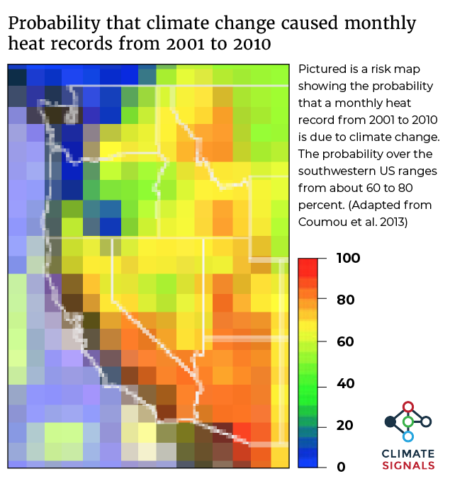
Around 80 percent of monthly hot temperature records in the Southwest from 2001 to 2010 were due to climate change.[1] Four out of five record-hot days globally are now amplified by the trend in global warming.[2]


Climate science at a glance
 Heat waves are more frequent across the US since the 1960s, with western regions setting records for numbers of these events in the 2000s.[1]
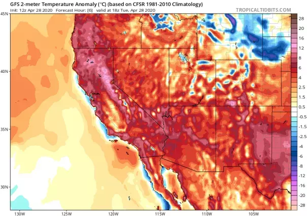
- In the Southwestern US, 60 to 80 percent of monthly temperature records during the decade 2001 to 2010 were due to climate change (pictured right).[2]
- For nearly four decades, the average annual temperature in NOAA’s Southwest climate region has increased by 0.6°F per decade relative to the average annual temperature during 1951 to 1980. For context, the global average temperature has increased at a rate of roughly 0.27 to 0.36°F per decade.
- The April 2020 southwestern heat wave is just the latest in what has become a new normal: record-breaking heat during the pre-monsoon season in the Southwestern US. See the following links for pre-monsoon heat waves in the region in 2019, 2018, 2017, and 2016.
Background: high pressure systems
Atmospheric pressure is an indicator of weather. To understand the types of weather conditions generally associated with high and low pressure systems, it helps to think “vertically.”
A high pressure system has higher pressure at its center than the areas around it. When a high pressure system develops in the upper atmosphere, the air below it sinks and compresses because there is more weight on top. This causes temperatures in the lower atmosphere to heat up. High pressure also pushes the jet stream and its drier, cooler air, farther north.
The jet stream is increasingly going off its traditional course and sometimes stalls altogether, and there is a growing body of evidence connecting this change in jet stream behavior to climate change.[3][4] When the jet stream stalls, high pressure ridges get ‘stuck’, leading to longer and more intense heat waves.
Climate signals breakdown
Climate Signal #1: Extreme heat and heat waves
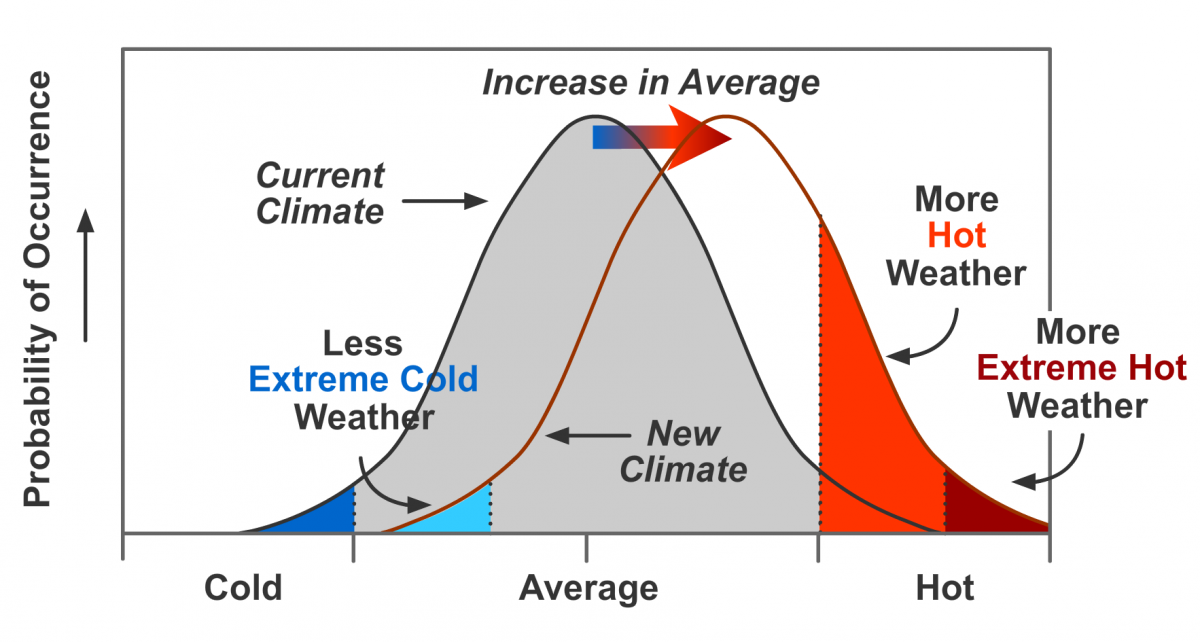 Record breaking temperatures are a classic signal of climate change. As the average global temperature rises and the climate shifts, hot temperatures that were extreme under the old climate are closer to the middle of the new temperature range.[5] Under the earth's climate system, events closer to the midpoint of the climate range occur much more frequently than events closer to the extremes, as shown in the graphic on the right. The shifting bell curve also leads to the occurrence of never-before-seen extremes in high temperatures.[6]
Observations consistent with climate signal #1
- States from California to Texas experienced temperatures 10 to 25°F above average.
- Phoenix recorded its first 100-degree day of the year on April 26, soaring to a daily record of 102°F. The city reached 102 degrees again on April 27.[7]
- Daily record highs starting falling in the Southwest on Friday, April 24, and continued through the following week.
- By Thursday, April 30, at least nine cities had tied or broken their all time April record high. The Weather Channel has a roundup of specific records broken.
Climate Signal #2: Atmospheric blocking increase
Climate change is altering atmospheric circulation (e.g. the jet stream), and some of these changes are dramatically amplifying local heat extremes.[4] There is increasing evidence suggesting that rising temperatures increase the risk of planetary wave stalling.[3] Planetary waves are a pattern of winds, of which the jet stream is a part, that encircle the northern hemisphere in lines that move from the tropics to the poles. Normally, the whole wave moves eastwards but, under certain temperature conditions, the wave can halt its movement. This leaves whole regions under the same weather for extended periods, which can turn hot spells into heatwaves and wet weather into floods.[3]
Studies have shown that the strength of these persistent weather patterns has trended upward in recent decades. One analysis identifies an increase in the intensity of persistent high pressure areas over the entire Northern Hemisphere during the summer months from 1979 to 2010.[6]
Observations consistent with climate signal #2
- For most of April, a high-pressure system was situated over the Gulf of Alaska, but it has now shifted into the western Lower 48 states. This is allowing a dome of hot air to build over the Southwest, which will then spread into the Rockies and parts of the Southern Plains this week.[7]


