Science Source
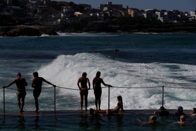
Marine heatwaves exacerbate climate change impacts for fisheries in the northeast Pacific
Study key findings & significance
Related Content
Science Source
| Science of The Total Environment
A quantitative analysis of marine heatwaves in response to rising sea surface temperature
Headline
Mar 22, 2023 | Washington Post
Earth’s oceans are showing early and surprising record warming
Headline
May 25, 2022 | Climate Nexus Hot News
NOAA Forecast Busier Than Average Atlantic Hurricane Season For 7th Year In A Row
Science Source
| Advances in Atmospheric Sciences
Another Record: Ocean Warming Continues through 2021 despite La Niña Conditions
Lijing Cheng, John Abraham, Kevin E. Trenberth et al
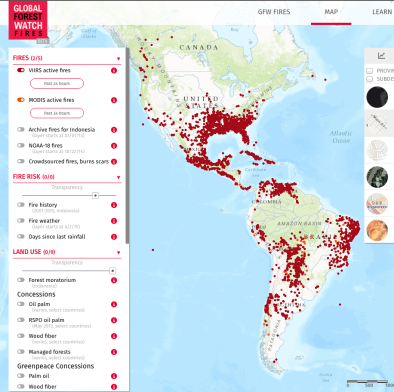
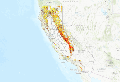
UPDATED Aug 2021: California's 20 Largest Wildfires
Event
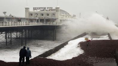
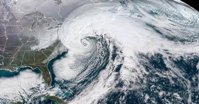
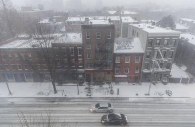
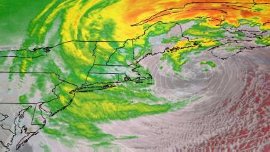
Eastern US Arctic Invasion and Winter Storm January 2018
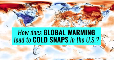
The intense cold hitting the United States during the first week of 2018 continued with a heavy snowstorm that inundated the Northeast seaboard beginning the night of January 3 through January 4. The combined impact of the arctic outbreak and the intensified nor’easter landed a double whammy in which new record low temperature records were set.
Science studies and models report that the outbreak of arctic air bringing freezing temperatures to the lower United States is consistent with the climate disruption expected on a warming planet where the Arctic heats up faster and cold air is displaced to the south.
Unusually warm offshore waters also amplified the temperature contrast between land and ocean surfaces. This temperature contrast is what generally fuels nor’easters. These conditions over the Atlantic are consistent with the long-term climate change trends that intensify nor’easters.
While climate change warms the planet as whole, it also disrupts regional weather patterns, sometimes displacing cold air to the south. The overall warming trend continues but cold conditions can move. The record setting heat events recently observed further north in parallel to cold conditions in the continental US are consistent with this pattern of disruption.
Jan 28, 2019 | NPR
Scientists Say A Fluctuating Jet Stream May Be Causing Extreme Weather Events
Jan 17, 2018 | Weather Underground | Category 6
Extreme Temperature Workout: The Gyrations of January 2018

Jan 11, 2018 | The Weather Channel
66 Consecutive Hours of Snow? It Happened in Syracuse, New York, Last Week
Resource
Mar 6, 2019 | Climate Signals | Climate Nexus
Video: How does global warming lead to cold snaps in the U.S.?
Resource
Jan 30, 2018 | CNBC via NASA
Photos: NASA took pictures of the bomb cyclone from space and they’re wild to see
Resource
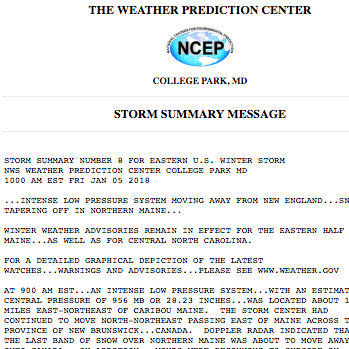
Jan 8, 2018 | The Weather Prediction Center
Storm Summary: Number 8 for eastern US Winter Storm
Nov 7, 2018 | Science Advances
Projected changes in persistent extreme summer weather events: The role of quasi-resonant amplification
Oct 2, 2018 | Geophysical Research Letters
North American weather regimes are becoming more persistent: Is Arctic amplification a factor?
Aug 30, 2018 | Science Advances
A stratospheric pathway linking a colder Siberia to Barents-Kara Sea sea ice loss
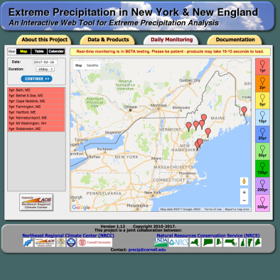
Feb 21, 2017 | Northeast Regional Climate Center (NRCC) | Natural Resources Conservation Service (NRCS)
New York and New England Extreme Precipitation
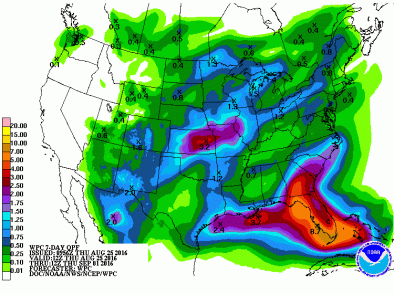
Aug 25, 2016 | Weather Prediction Center
US Quantitative Precipitation Forecasts
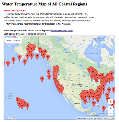
Jul 15, 2016 | NOAA / NODC
US Coastal Water Temperatures
Related Content
Headline
Jan 9, 2018 | WNCT9
Climate change continues despite record cold snap
Headline
Jan 9, 2018 | Wall Street Journal
Why Did New England Gas Prices Jump Nearly 90%? Blame Severe Storm
Headline
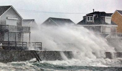
Jan 8, 2018 | The Weather Channel
Winter Storm Grayson's Bombogenesis Brought Whiteout Conditions From Virginia to New England, Record Coastal Flooding at Boston Harbor
Headline
Jan 8, 2018 | Weather Underground | Category 6
January Thaw in Sight after Two-Week Wintry Onslaught and “Bomb Cyclone” by Bob Henson
Event
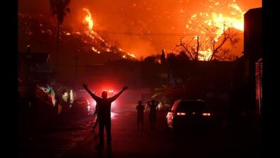
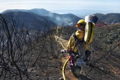
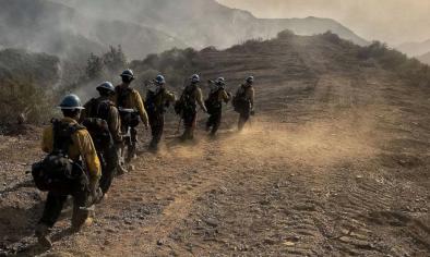
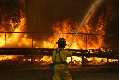
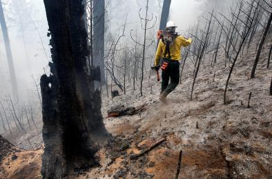
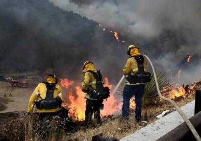
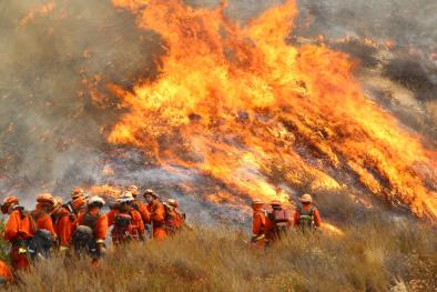
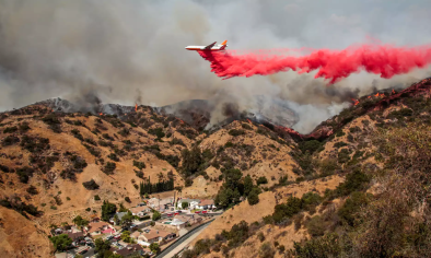
Thomas Fire 2017
Higher temperatures, drier conditions, increased fuel availability, and growing warm seasons—all linked to climate change—are increasing wildfire risk in California.
In 2017, the combination of a wet winter followed by extreme heat and dry conditions has fueled record wildfires in many Western states.[1]
In early December, a series of fires extended this trend when they erupted in the mountains north of Ventura and Los Angeles, California.
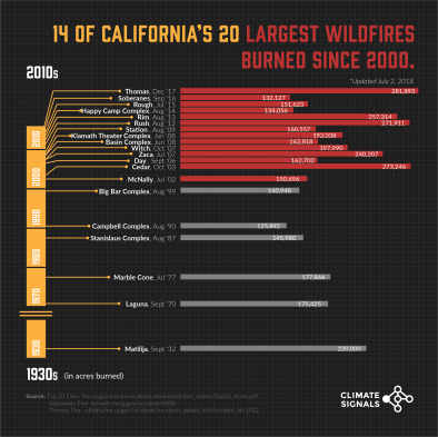
The Thomas Fire, which began on the evening of December 4, is the largest blaze and grew quickly to nearly 31,000 acres (50 square miles) in less than 12 hours.[2] As of January 1, 2018, the Thomas Fire was 92 percent contained and had burned 281,893 acres establishing it as largest fire in California recorded history.[3][4] A mixture of dry foliage, low humidity and high sustained winds of more than 30 miles per hour led to its explosive growth, according to Fire Sgt. Eric Buschow.[5] Other major fires included the Creek and Rye events.
Research indicates a direct causal link between human-induced climate change and increased wildfire risk in California.[6] Climate change has contributed to California's longer fire seasons, the growing number and destructiveness of fires and the increasing area of land consumed.[7][8]
May 24, 2018 | New York Times
The Places in the U.S. Where Disaster Strikes Again and Again
Jan 1, 2018 | Weather Underground | Category 6
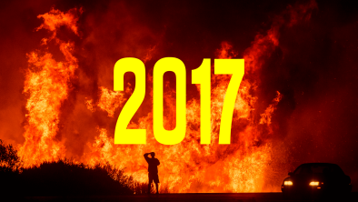
Top Ten Global Weather/Climate Events of 2017: A Year of Landfalls and Firestorms
Jan 2, 2018 | Climate Central
The 10 Most Important U.S. Climate Stories in 2017

Resource
Mar 30, 2018
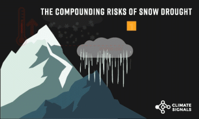
GIF: The Compounding Risks of Snow Drought
Resource
Dec 15, 2017 | The Guardian
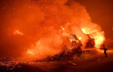
Photos: California's Thomas wildfire enters its second week
Resource
Dec 8, 2017 | Climate Signals | CalFire
Chart: 14 of California's 20 largest wildfires burned since 2000
Dec 5, 2017 | Journal of Arid Environments
Trends and drivers of fire activity vary across California aridland ecosystems
Dec 11, 2017 | Environmental Research Letters
Future respiratory hospital admissions from wildfire smoke under climate change in the Western US
Oct 10, 2016 | Proceedings of the National Academy of Sciences
Impact of anthropogenic climate change on wildfire across western US forests

Related Content
Headline
Dec 21, 2017 | LA Times
Gov. Jerry Brown requests a major disaster declaration for SoCal wildfires
Headline
Dec 21, 2017 | SFGate
Thomas Fire on verge of becoming the biggest blaze in state history
Headline
Dec 20, 2017 | ABC News
Thomas fire in California now the 2nd largest in state's history
Headline
Dec 20, 2017 | ThinkProgress
Western states lived with a constant reminder of climate change in 2017
Event
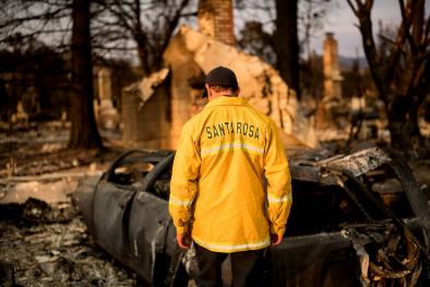
California Wine Country Fires October 2017
Trends in California driven by climate change—including higher temperatures and drier conditions—are elevating the risk of dangerous and destructive wildfires across California and the western United States.
On October 8, a group of fires exploded across a wide swath of Northern California.[1] Taken as a group, the fires are among the worst on record in the state in terms of lives and property lost.[2][3] After just one week, the fires have killed at least 41 people, burnt more than 200,000 acres, destroyed or damaged more than 5,500 homes, and displaced 100,000 people.[4] Governor Jerry Brown declared a state of emergency in Butte, Lake, Mendocino, Napa, Nevada, Orange, Sonoma and Yuba counties.[5]
By the end, the Wine Country fires killed 42 people, destroyed 8,700 homes and buildings, and burned 245,000 acres.[6] The event was deadliest, most destructive, and one of the largest fires in California history.[7][8][9][10]
The combination of a wet winter followed by extreme heat and dryness has fueled record wildfires in many Western states.[11] Climate change compounds the risks of wildfires by extending the length of the fire season and adding to the intensity of droughts and heat waves. Park Williams, a climate and drought expert, noted, “... the combination of dry fuel, extreme heat and climate change is a recipe for what we are seeing."[12]
May 24, 2018 | New York Times
The Places in the U.S. Where Disaster Strikes Again and Again
Jan 1, 2018 | Weather Underground | Category 6
Top Ten Global Weather/Climate Events of 2017: A Year of Landfalls and Firestorms
Dec 20, 2017 | ThinkProgress
Western states lived with a constant reminder of climate change in 2017
Resource
Nov 7, 2017 | Climate Central
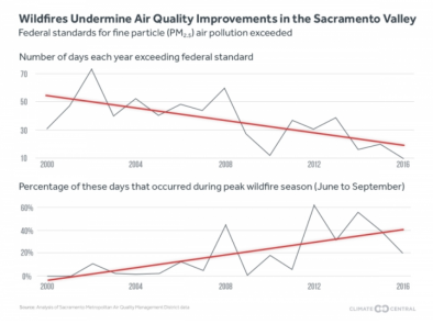
Report: Western Wildfires Undermining Progress on Air Pollution
Resource
Oct 19, 2017 | Climate Nexus
Media Briefing: Climate Change and Wildfires, 10-18-2017
Resource
Oct 19, 2017 | Bay Area Quality Management District
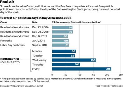
Chart: 10 worst air-pollution days in the Bay Area since 2003
Oct 10, 2016 | Proceedings of the National Academy of Sciences
Impact of anthropogenic climate change on wildfire across western US forests
Jun 23, 2016 | Climate Central
Western Wildfires: A Fiery Future
Jul 1, 2016 | Bulletin of the American Meteorological Society
EEE 2014: Extreme Fire Season in California: A Glimpse Into the Future?
Related Content
Headline
Dec 5, 2017 | The Mercury News
Ratepayers should not have to pay for utilities’ wildfires negligence
Headline
Dec 5, 2017 | SFGate
Wine Country fires destroyed 8,889 structures
Headline
Dec 1, 2017 | Vox
It's official: this was California's worst fire season ever
Headline
Nov 28, 2017 | San Francisco Chronicle
Huge wildfires can wipe out California’s greenhouse gas gains
Event
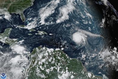
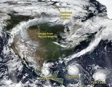
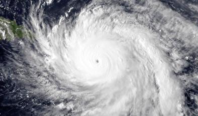
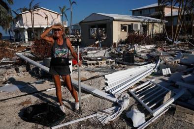
Hurricane Maria 2017
The record-breaking rainfall and flooding driven by Hurricane Maria—as well as Hurricanes Harvey and Irma just weeks before—is consistent with the long-term trend driven by climate change.
Hurricane Maria made landfall in Dominica as a Category 5 hurricane on September 18,[1] then hit southeast Puerto Rico on September 20 with 155 mph winds and a central pressure of 917 millibars.[2] It was the third strongest storm to make landfall in the United States.[3] "1,000-year" rains inundated much of eastern and northwestern Puerto Rico.[4] The storm knocked out power to the entire island of Puerto Rico, home to 3.5 million people, leading to a prolonged humanitarian crisis.[5]
Extreme rainfall is increasing worldwide due to climate change. In Puerto Rico, rain falling in very heavy events increased at least 33 percent from 1958-2012. Seas are now higher due to global warming, so storm surge drives much further inland. There has also been a global increase in the observed intensity of the strongest tropical cyclones, correlated with observed trends in sea surface temperatures in recent decades.
Apr 17, 2019 | Weather Underground
Climate Change Made Hurricane Maria’s Heavy Rains Nearly 5 Times More Likely to Occur
Jul 11, 2018 | ThinkProgress
Beryl is proof that even the smallest storm can be a threat to Puerto Rico
Jun 15, 2018 | Thomson Reuters Foundation
In Puerto Rico, a new hurricane season threatens the elderly

Resource
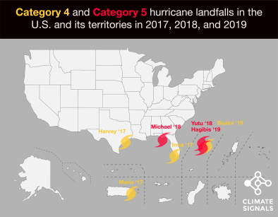
Nov 14, 2019 | NOAA hurricane research division
[INFOGRAPHIC] Category 4 and 5 U.S. hurricane landfalls in 2017, 2018, and 2019
Resource

Dec 4, 2019
[REPORT] NOAA Tropical Cyclone Report: Maria
Resource
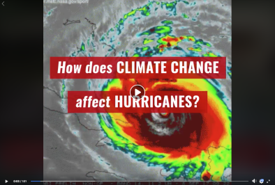
Jun 11, 2018 | Climate Signals | Climate Nexus
Video: How Climate Change Affects Hurricanes
Apr 18, 2019 | Geophysical Research Letters
Extreme Rainfall Associated With Hurricane Maria Over Puerto Rico and Its Connections to Climate Variability and Change
Nov 14, 2018 | Nature
Anthropogenic influences on major tropical cyclone events
May 9, 2018 | Geophysical Research Letters
Increasing Magnitude of Hurricane Rapid Intensification in the Central and Eastern Tropical Atlantic
Related Content
Headline

Feb 12, 2018 | NPR
Explosion At Substation Plunges Parts Of Puerto Rico Into Darkness Once Again
Headline
Jan 23, 2018 | Nature
Atlantic hurricanes' rapid growth spurts are intensifying
Headline
Jan 16, 2018 | Weather Underground
The Three Category 5 Tropical Cyclones of 2017
Headline
Dec 13, 2017 | Wall Street Journal
A Year Punctuated by Tragedy
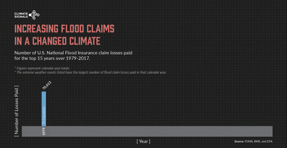
Chart: Increasing flood claims in a changed climate
Animated GIF
[published Nov 2017]
NFIP claims rise alongside upward trends in extreme storm frequency . . .
The increasing frequency of US National Flood Insurance Program (NFIP) claims parallels the increasing frequency of extreme rainfall and flooding in the United States.
Event
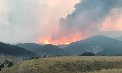
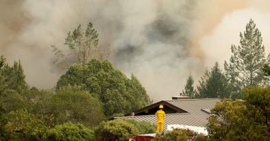
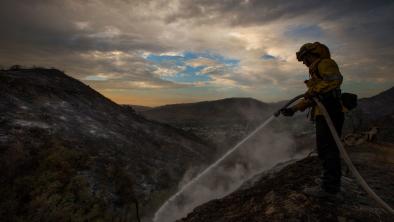
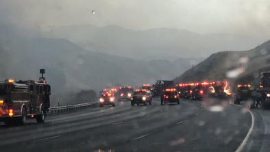
La Tuna Fire September 2017
Higher temperatures and drier conditions—both linked to climate change—are increasing wildfire risk in California.
The La Tuna Fire erupted north of downtown Los Angeles and, at more than 7,000 acres, the fire is the largest to burn within Los Angeles' city limits.[2]
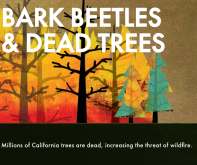
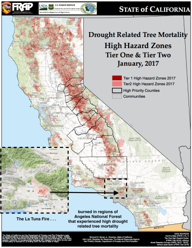
While small compared to the biggest fires in California's history,[1] the La Tuna Fire is notable for its proximity to a major city and its rapid growth amid unseasonably warm temperatures. The fire also erupted at the edge of the Angeles National Forest, a region where bark beetle activity has increased in recent years of extreme heat and drought.
Sep 11, 2017 | Daily News
La Tuna fire 100 percent contained, LAFD says
Sep 5, 2017 | CBS News
La Tuna fire tears through 7,000 acres and 3 homes
Sep 5, 2017 | latimes.com
Weather delivers blow to La Tuna fire's spread: 'Mother Nature kicked in'
Resource
Sep 5, 2017 | Cal Fire TV
Video: California Drought and Bark Beetles
Resource
Sep 5, 2017 | Cal Fire | US Forest Service
Map: Drought Related Tree Mortality near La Tuna Fire
Resource
Sep 5, 2017 | The Guardian
Photos: Firefighters tackle Burbank's La Tuna fire
Jun 23, 2016 | Climate Central
Western Wildfires: A Fiery Future
Jun 29, 2016 | Plos One
Incorporating Anthropogenic Influences into Fire Probability Models: Effects of Human Activity and Climate Change on Fire Activity in California
Jul 1, 2016 | Bulletin of the American Meteorological Society
EEE 2014: Extreme Fire Season in California: A Glimpse Into the Future?
Related Content
Headline
Sep 4, 2017 | Los Angeles Times
Record heat, lightning, fires, intense rain: California's extreme weather gets wilder
Science Source
| Science
Warming and Earlier Spring Increase Western U.S. Forest Wildfire Activity
A. L. Westerling, H. G. Hidalgo, D. R. Cayan et al
Science Source
| Geophysical Research Letters
Large wildfire trends in the western United States, 1984–2011
Dennison, Philip E., Brewer et al
Science Source
| Geophysical Research Letters
Running dry: The U.S. Southwest's drift into a drier climate state
Prein, Andreas F., Holland et al
Event
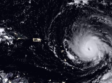
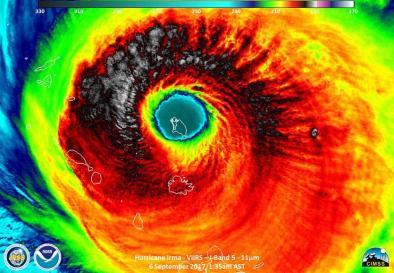
Hurricane Irma 2017
Overview
Climate change is amplifying the damage done by hurricanes, by elevating sea levels and thus extending the reach of storm surge, and by loading storms with additional rainfall and thereby increasing flood risk.
Climate change may also be driving the observed trend of increasing hurricane intensity[1] as well as the observed trend of more rapidly intensifying hurricanes.[2][3]
In addition there is significant evidence linking climate change to the observed shift in the track of hurricanes such as Irma toward the US coast.[4]
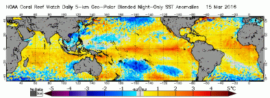
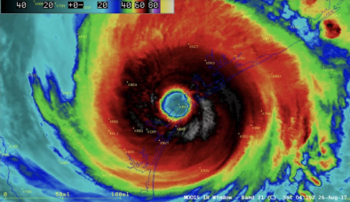
Hurricane Irma maintained maximum wind speeds of at least 180 mph for 37 hours, longer than any storm on Earth on record, passing Super Typhoon Haiyan, the previous record holder (24 hours).[5] Irma’s maximum accumulated energy over 24 hours was the highest for any Atlantic hurricane on record.[9] The storm intensified into a Category 5 with 185 mph winds on September 5, making it the most powerful Atlantic hurricane ever recorded outside of the Caribbean and Gulf of Mexico where warmer waters make those areas more prone to stronger cyclones.[6]
Hurricanes are fueled by available heat. As global warming heats sea surfaces, the energy available to power hurricanes increases, raising the limit for potential hurricane wind speed.[7]
Irma intensified in the Atlantic from September 4 to 5 as it entered a region of sea surface temperatures ranging from 0.9°F to 2.25°F (0.5°C to 1.25°C) above average, relative to a 1961-1990 baseline.[8]
Aug 27, 2019 | CNN
4 employees to face charges in Florida nursing home deaths after Hurricane Irma, lawyer says
Jun 15, 2018 | Thomson Reuters Foundation
No vacancy: Housing crisis dogs Florida Keys months after Irma
May 24, 2018 | New York Times
The Places in the U.S. Where Disaster Strikes Again and Again
Resource
Nov 14, 2019 | NOAA hurricane research division
[INFOGRAPHIC] Category 4 and 5 U.S. hurricane landfalls in 2017, 2018, and 2019
Resource
Jun 11, 2018 | Climate Signals | Climate Nexus
Video: How Climate Change Affects Hurricanes
Resource
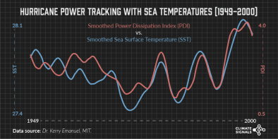
Sep 29, 2017 | Climate Signals via Dr. Kerry Emanuel, MIT
[GIF] Hurricane Power Tracking with Sea Temperatures (1949 - 2000)
Nov 14, 2018 | Nature
Anthropogenic influences on major tropical cyclone events
May 9, 2018 | Geophysical Research Letters
Increasing Magnitude of Hurricane Rapid Intensification in the Central and Eastern Tropical Atlantic
Jan 25, 2017 | Bulletin of the American Meteorological Society
EEE 2015: Influences of Natural Variability and Anthropogenic Forcing on the Extreme 2015 Accumulated Cyclone Energy in the Western North Pacific
Related Content
Headline

Oct 19, 2017 | InsideClimate News
Florida’s Migrant Farm Workers Struggle After Hurricane Damaged Homes, Crops
Headline

Sep 29, 2017 | Category 6 | Weather Underground
Lake Okeechobee Nears Highest Water Level in 10 Years
Headline

Sep 28, 2017 | Vox
The torrential rain from Hurricanes Maria, Irma, and Harvey is a strong signal of climate change
Headline

Sep 26, 2017 | The Weather Channel
September 2017 Was the Most Active Month on Record for Atlantic Hurricanes
Event
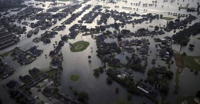
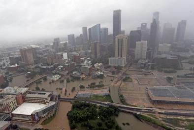
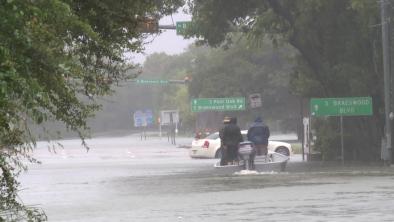
Hurricane Harvey 2017
Climate change raises or amplifies the three primary hazards associated with hurricanes: storm surge, rainfall, and the power ceiling, aka potential speed limit, for hurricane winds.
In the case of Hurricane Harvey, extreme precipitation was most notable. Harvey set a new national tropical cyclone rainfall record of 60.58 inches near Nederland, Texas.[1] At least five attribution studies found that global warming added to the deluge of rainfall dumped by Hurricane Harvey., and climate change was responsible for up to $67 billion of Harvey's $90 billion price tag.[2] A warmer atmosphere holds more water vapor, feeding more precipitation into all storms including hurricanes, significantly amplifying extreme rainfall and increasing the risk of flooding.[3][4]
In addition to extreme precipitation, Harvey intensified rapidly amid sea surface temperatures in the Gulf of Mexico up to 2.7 - 7.2°F (1.5 - 4°C) above average, relative to a 1961-1990 baseline.[5] As climate change warms sea surfaces, the heat available to power hurricanes has increased, raising the limit for potential hurricane wind speed and with that an exponential increase in potential wind damage.
Apr 8, 2020 | Houston Public Media
In Houston, Coronavirus Tests A City Known For Its Resilience
Jun 6, 2018 | LA Times
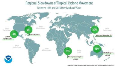
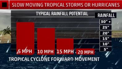
Hurricanes and typhoons are slowing down, which means more time to do damage
Jun 6, 2018 | KPRC
Report gives new insight into just how bad Hurricane Harvey was
Resource
Nov 14, 2019 | NOAA hurricane research division
[INFOGRAPHIC] Category 4 and 5 U.S. hurricane landfalls in 2017, 2018, and 2019
Resource
Jun 11, 2018 | Climate Signals | Climate Nexus
Video: How Climate Change Affects Hurricanes
Resource
Jun 6, 2018 | KPRC
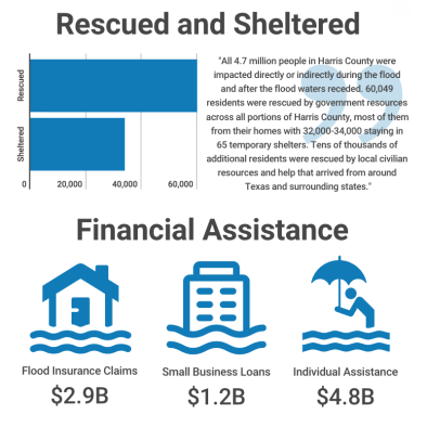
Infographic: Hurricane Harvey Impacts
Apr 10, 2020 | Climatic Change
The economic costs of Hurricane Harvey attributable to climate change
May 4, 2020 | Disaster medicine and public health preparedness
A Spatial and Temporal Investigation of Medical Surge in Dallas-Fort Worth During Hurricane Harvey, Texas 2017
Jun 6, 2018 | Nature
A global slowdown of tropical-cyclone translation speed
Related Content
Headline
May 23, 2018 | The Weather Channel
Why Intensity Doesn't Matter Much for Tropical Rainfall Potential
Science Source
| Earth's Future
Hurricane Harvey links to Ocean Heat Content and Climate Change Adaptation
Kevin E. Trenberth, Lijing Cheng, Peter Jacobs et al
Headline
May 9, 2018 | Washington Post
Because of climate change, hurricanes are raining harder and may be growing stronger more quickly
Science Source
| Submitted: Environmental Research Letters
Attribution of climate effects on Hurricane Harvey's extreme rainfall in Texas
S.-Y. Simon Wang, Lin Zhao, Jin-Ho Yoon et al
