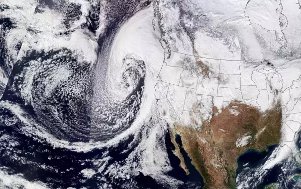
California Atmospheric Rivers January 2023
From late December 2022 through mid-January 2023, California was hit by repeated storms fueled by torrents of moisture called atmospheric rivers. Climate change likely made the storms more intense with lower pressure and higher precipitation. The storms brought a wide variety of hazardous weather to the Bay Area and California's Central and Northern Coasts, leading to flooding, storm surge, and strong winds. Climate change is fundamentally “loading the dice,” increasing the chance for intense storms like these to form, ultimately leading to a growing risk of property damage and loss of life.


Climate science at a glance
- Atmospheric rivers are central to water resource management in the western United States.
- Anthropogenic climate change has and continues to alter these storms, which has a cascade of societally relevant impacts.
- Atmospheric rivers in the western U.S. warmed substantially from 1980 to 2016.
- As the climate warms, atmospheric rivers are expected to form in more rapid succession and grow more intense as they become wetter, longer, and wider.
- Human-caused climate change has increased the extremes between periods of drought and periods of high precipitation.
- The chance of going back and forth between major drought to high precipitation events more suddenly than normal is increasing.
- Human-caused global warming has been linked to an increase in the amount of moisture in the atmosphere, which means atmospheric river storms can funnel more atmospheric moisture inland than it would in the absence of climate change, leading to abnormally high precipitation rates.
Climate signals breakdown: how is this event consistent with climate trends?
Atmospheric River Change
- A ClimaMeter attribution analysis found that "rainfall events similar to the December 26, 2022 - January 10, 2023 California atmospheric river are more intense with lower pressure (2 hPa) and higher precipitation (1 mm/day to 5 mm/day) in the present than in the past."
- A climate attribution analysis finds that "rainfall events similar to the 9-10 January 2023 California atmospheric river are more intense with lower pressure (3 hPa) and higher precipitation ( 5 mm/day to 15 mm/day) in the present than in the past."
- Katerina Gonzales: "The atmospheric rivers are coming in a row, and they are really strong and really wet. This convergence is the heart of the matter. It’s unusual that there are so many storms and that they are super juicy. Mountains usually wring the water out of atmospheric rivers. But a lot of the moisture from last week’s storms in California made it to Minnesota, dropping a foot and a half of snow. There’s so much moisture in the system; it’s anomalous that there’s so much."
Weather Whiplash
- This water year, the pendulum of California weather has swung from record dry to exceptionally wet. The record-breaking series of atmospheric river storms came just after the state’s three driest consecutive years on record (2020-2022).
Increase in Atmospheric Moisture & Extreme Precipitation Increase
- Between December 26th, 2022, and January 17th, 2023, Downtown San Francisco received 17.64" of rain. SFO Airport set a 23-day rainfall record at 15.28", while the city of Oakland set their own 23-day rainfall record with 18.33" of rain.
- The State maximum total rain was in Honeydew, California (Humboldt County) which received 47.74" since December 26th. Many of the area coastal peaks as well as the Sierra Nevada received between 20" to 35" of rain!

Rose Andreatta
Rose Andreatta is the director of the Climate Signals project and has over a decade of experience translating scientific information into usable formats for a variety of audiences. Rose earned her Master’s of Public Administration in Environmental Science and Policy at Columbia University and holds a Certificate of Achievement in Weather Forecasting from Pennsylvania State University.


