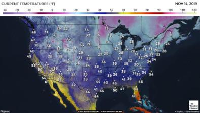
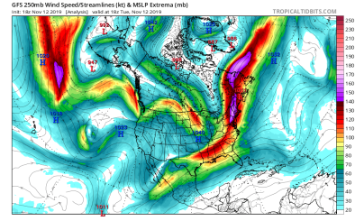
Extreme Cold in the eastern US November 2019
A dip in the jet stream has brought Arctic air and record-breaking cold to the eastern US. How do you explain extreme cold in a world that's getting hotter? Arctic blasts can still occur in a warming world, and there is a growing body of evidence showing that climate change could actually make frigid waves of Arctic air more common, a result of shrinking sea ice.


Climate science at a glance
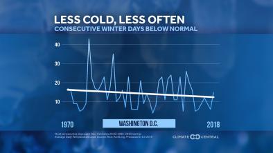
Over the long-term, data shows cold outbreaks of this severity are becoming rarer, as warm-temperature records outpace cold records by an increasingly large margin.
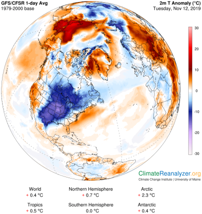
- While North America experienced cold Arctic air, most of the world was abnormally hot.
- Nationwide, warm records have been outpacing cold by a 2-to-1 margin over the past decade. In a stable climate, this should come out about evenly over the long term.
- Data shows that since 1970, winter cold streaks are lasting for at least one day shorter in most US cities, with an average reduction of nearly five days.[1]
- According to the 4th US National Climate Assessment, “Heatwaves have become more frequent … since the 1960s, while extreme cold temperatures and cold waves are less frequent.”[2]
Global warming is messing with atmospheric circulation, including the jet stream.
- Atmospheric blocking due to anomalous, persistent, meandering of the jet stream often causes weather extremes in the midlatitudes.[3]
- Studies have linked record warm temperatures in the Arctic to changes in atmospheric circulation patterns in the midlatitudes.
- Changes in the jet stream are leading to increased weather extremes of various types, including increases in some extreme winter events.[4]
Climate signals breakdown
Climate signals #1 and #2: Arctic amplification and large scale global circulation change
Disruptions to the natural cycles of arctic sea ice, land ice, surface temperature, snow cover, and permafrost affect the amount of warming, sea level change, carbon cycle impacts, and potentially even weather patterns in the lower 48 states.[2] Recent studies have linked record warm temperatures in the Arctic to changes in atmospheric circulation patterns in the midlatitudes.[2][5]
Arctic warming is linked to the frequency and intensity of severe winter storms in the United States.[6][7]
Observations consistent with climate signals #1 and #2
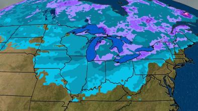
- The Arctic blast broke daily snowfall records across the Midwest and East. The Buffalo News called the storm "record-shattering," saying it broke a Nov. 11 snowfall total that had stood for the city for 77 years. In the Chicago area, a storm being dubbed "snowvembruary" set single-day snowfall records for Nov. 11 at Chicago's O'Hare airport (3.4 inches) and in Rockford, Ill., (3.2 inches).[8]
- In all, the Arctic outbreak tied or broke over 400 cold-temperature records, including all-time November records, across a broad swath of the country.[9]
Climate signal #3: Atmospheric blocking increase
One pathway by which global warming is influencing extremes is through dynamic effects, which are changes having to do with the effects of forces on the motion of objects. There has been an increase in the frequency of ridging patterns—such as the one bringing extreme cold to the eastern US—that are creating warm conditions in the West and colder conditions in the East.[4]
Atmospheric blocking occurs when waviness in the jet stream causes congestion. Blocking events are associated with long-lasting and slow-moving high-pressure systems that "block" westerly winds in the mid- and high-latitudes, causing the normal eastward progress of weather systems to stall. A major block can produce long stretches of blazing heat in the summer or bitter cold in the winter.[10]


