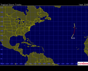
Hurricane Nicole 2016
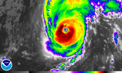
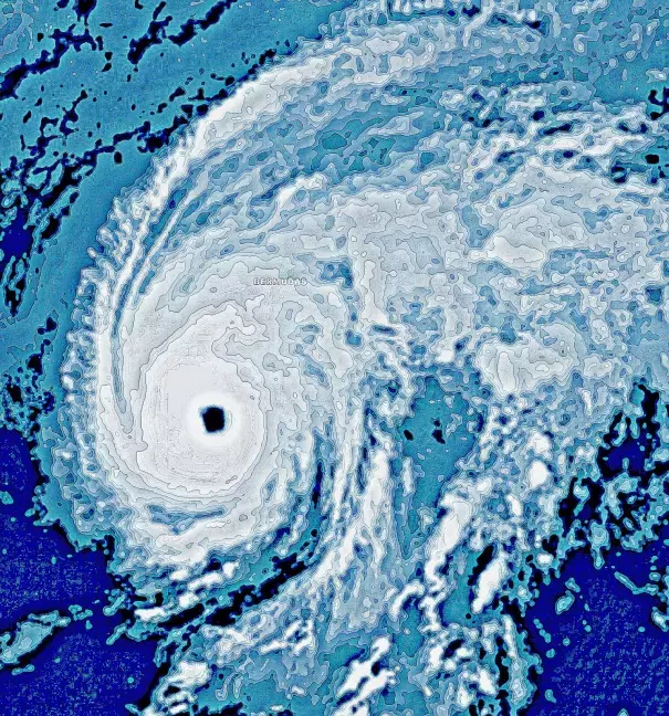
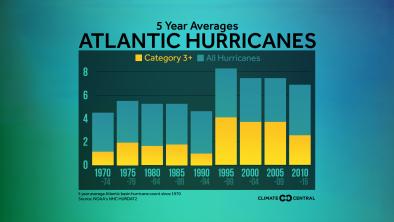
Hurricane Nicole intensified into Category 3 Hurricane on the evening of October 12 before bearing down on Bermuda. Nicole marked the 3rd major hurricane of the North Atlantic season, qualifying 2016 as an above average hurricane season, and marking the most major hurricanes in a season since 2011.
On October 12, Nicole also pushed the Atlantic's Accumulated Cyclone Energy for October up to the most for any October since 1963. Nicole's tremendous power and sustained strength, fueled by historically warm seas, are consistent with the observed trends in the Atlantic since the 1970's. There is a significant risk that this trend is driven by global warming.
Climate science at a glance
- Sea level rise is increasing the reach of storm surge and flooding driven by hurricanes.
- Global warming loads hurricanes with more rainfall, increasing the threat of flooding.
- Hurricanes are growing stronger. There is a significant risk global warming is driving that trend.
Sea level rise fuels storm surge and flooding
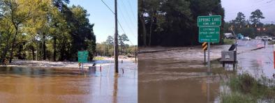
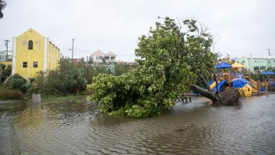
Hurricanes now ride atop elevated sea levels, contributing to storm tides and flooding, the leading cause of hurricane storm damage and fatalities.
Sea levels are now .67 feet higher due to sea level rise,[1] an increase that drives flooding much further inland along low-lying areas.[2] NOAA reports that so-called "nuisance flooding," e.g. coastal flooding during king tides, has already increased 300 to 925 percent due to sea level rise to date.[3] A small vertical increase in sea level can translate into a large increase in horizontal reach by storm surge depending upon local topography. For example, sea level rise extended the reach of Hurricane Sandy by 27 square miles, affecting 83,000 additional individuals living in New Jersey and New York City.[4]
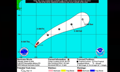
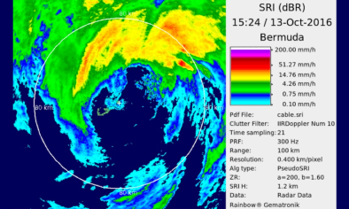
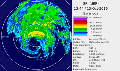
A NOAA advisory issued late on October 12 warned dangerous storm surge will raise water levels by as much as 6 to 8 feet above normal tide levels in Bermuda, accompanied by large and destructive waves.
Global warming supercharging rainfall
One of the clearest changes in weather globally is the increasing frequency of heavy rain. [1] Over the last three decades, extreme and record-breaking rainfall events have significantly globally, and the fingerprint of global warming has been firmly documented in this pattern. Moreover, the size of the contribution by climate change to extreme rainfall has been very significant. Climate change is now responsible for 17 percent of moderate extreme rainfall events, i.e. 1-in-3 year events. The more extreme the event, e.g, 1-in-30 year events, the more likely climate change is responsible, as climate change affects the frequency of the extreme events the most. [5][6]
Over the past century the US has witnessed a 20 percent increase in the amount of precipitation falling in the heaviest downpours. Over the period from 1994-2008, extreme precipitation events linked to hurricanes accounted for more than 33 percent of the observed increase in heavy events across the US.[7]
Unusually warm seas can help load moisture, driving evaporation to feed storms. In its approach to Bermuda, Nicole traveled over near-record-warm waters about 1.5 - 2.0°C above average for mid-October.[26]
As the global average temperature increases, so too does the ability of the atmosphere to hold and dump more water when it rains.[8] Atmospheric water vapor has been increasing.[9][10] And the observed increases have been studied and formally attributed global warming.[11][12][13]
A NOAA advisory issued late on Oct 12 warned that Nicole is expected to produce total rain accumulations of 4 to 8 inches over Bermuda through Thursday.
Storms reach out and gather water vapor over regions that are 10-25 times as large as the precipitation area, thus multiplying the effect of increased atmospheric moisture.[8] As water vapor condenses to form clouds and rain, the conversion releases heat that adds buoyancy to the air and further fuels the storm.[14] This increases the gathering of moisture into storm clouds and further intensifies precipitation.[8]
Nicole grew into a major hurricane
 Nicole's tremendous power and sustained strength are consistent with the observed trends in the Atlantic since the 1970's.[1] There is a significant risk that this trend is driven by global warming.[15][16]
Nicole marked the 3rd major hurricane of the North Atlantic season, qualifying 2016 as an above average hurricane season, and marking the most major hurricanes in a season since 2011.
As of early Oct. 12, Nicole's pressure intensity of of 962 mb was 7th lowest for a tropical cyclone in the Atlantic outside of the tropics (23.5°N) this late in the season (since 1979). And by October 12 the Atlantic's Accumulated Cyclone Energy for October reached 53 - the most for any October since 1963.
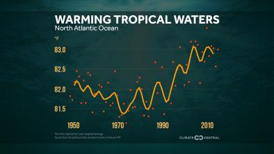
In its approach to Bermuda, Nicole traveled over near-record-warm waters of around 28 - 29°C (82 - 84°F), which is about 1.5 - 2.0°C above average for mid-October.[26]
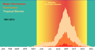
Virtually every measure of Atlantic hurricane activity since the 1970s has increased
There has been a substantial increase in virtually every measure of hurricane activity in the Atlantic since the 1970s, including measures of intensity, frequency, and duration as well as the number of strongest (Category 4 and 5) storms.[1][17]
Tropical cyclones are fueled by available heat. Warming seas are increasing the potential energy available to passing storms, effectively increasing the power ceiling or speed limit for these cyclones.[18] However, other factors, such as wind shear and the global pattern of regional sea surface temperatures, also play controlling roles. And the balance of these factors is not fully known.[19]
As seas warm and offer more heat energy, there has also been a global increase in the observed intensity of the strongest storms. The close correlation between observed trends in recent sea surface temperatures and observed trends in the intensity of tropical cyclones may reflect a causal link between warming ocean temperatures and stronger storms.[20][21] The increases are well-documented and are consistent with model projections for cyclones in a warming climate, but work continues to better understand the relation between these two trends.[18] However there is significant risk that these two trends are, in fact, causally related.
The U.S. National Climate Assessment (2014) reports that "the intensity, frequency, and duration of North Atlantic hurricanes, as well as the frequency of the strongest hurricanes, have all increased since the early 1980s." Significant evidence indicates that these increases are linked to higher sea surface temperatures in the region through which Atlantic hurricanes form and move.[20][22][23] However, this is an area of continuing study as numerous factors determine hurricane intensity and frequency, and global warming may be affecting these factors in conflicting ways.
For the most recent, detailed, consensus synthesis of the current science on climate change and tropical cyclones see, "Tropical cyclones and climate change," by Walsh et al, 2015.[18]
We know that the warmer the ocean surface, the more moisture and heat that's available to intensify hurricanes and typhoons.
Dr. Michael Mann [24]
If you put more heat energy into the air, you've got more energy available to power a stronger storm.
Dr. Jeff Masters [24]
The thermodynamic limit for this hurricane wind speed must go up as you warm the climate.
Dr. Kerry Emanuel [24]
Looking forward, there is a uniform projection by climate models that the frequency of the strongest cyclones will increase. Most models also project that the overall number of cyclones will decline even as the frequency of the most powerful storms increases. Unfortunately, these opposing trends may not balance out. The wind damage caused by hurricanes increases geometrically, becoming disproportionately greater as wind speed increases. Moreover, some results point to an increase in frequency across all storms.[18][25][15] There is a large uncertainty in these projections[18] which represents considerable risk.
Related Content