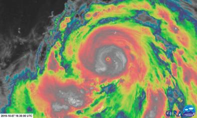
Dangerous and intensifying Typhoon Vongfong churns toward the Philippines

Climate Signals Summary: As climate change causes oceans to warm, surface waters have more energy to convert to hurricane winds, which is likely causing storms to rapidly intensify as well as increasing the overall intensity of the strongest storms, including typhoons in the Northwest Pacific.
Article Excerpt: Typhoon Vongfong is the first named storm of the 2020 West Pacific typhoon season, but it already has the makings of a potentially significant storm. The Philippines is bracing for a close shave or direct hit later this week as the intensifying system churns ominously closer to the archipelago.
...
According to the Joint Typhoon Warning Center (JTWC), Vongfong currently stands at Category 3 status, with maximum sustained winds of 120 mph and gusts to 150 mph. It’s moving to the west-northwest at 10 mph. Typhoon Vongfong has been undergoing rapid intensification and may outpace forecasts as its intensity ramps up.
...
The Joint Typhoon Warning Center wrote Wednesday that “the environment remains very favorable for additional rapid intensification,” with toasty water temperatures and favorable upper-level winds making for an atmospheric powder keg that the typhoon could very well take advantage of.
Studies have shown increases in the occurrence of rapidly intensifying storms in some parts of the world, defined as an increase in a storm’s maximum sustained winds of 35 mph or greater in 24 hours. One study of rapid intensification in the Atlantic that was published last year found that this is occurring due to climate change-induced changes in the ocean and atmosphere.
...
The JTWC expects Typhoon Vongfong to continue at Category 3 strength by Thursday afternoon or evening local time. During this time frame, Vongfong should track northwest, skimming the Philippines’ eastern Visayas and the Bicol region.
That probably means a very close shave of the western eyewall on the eastern shores of the island of Samar, where winds ranging from tropical storm to hurricane force and a storm surge of several feet are likely.
Related Content