California Bomb Cyclone and Atmospheric River October 2021
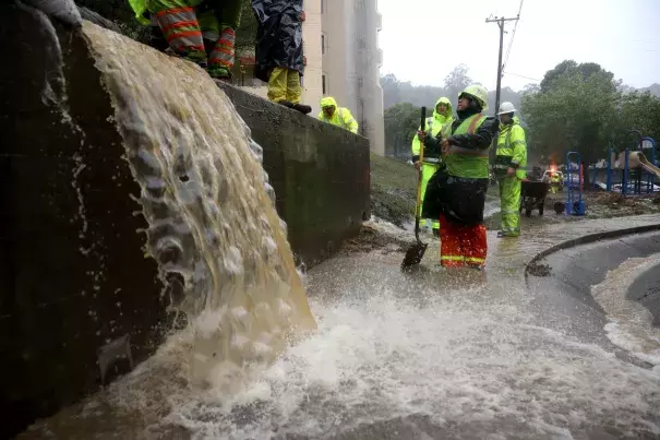
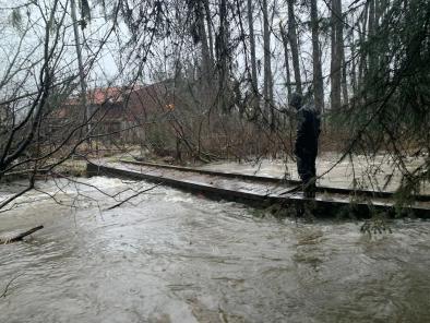
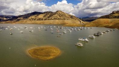
A record-strong bomb cyclone and intense atmospheric river inundated Northern California on October 24-25. The rain and snow effectively ended the record-breaking wildfire season in Northern California and brought badly needed water to the drought-stricken region. However, the extreme shift from drought to deluge – itself a signal of climate change – brought flash floods and debris flows along the burn scars of recent wildfires. 2021 has been a devastating year for the West Coast as human-caused climate change has fueled all-time record wildfires, heat, drought and now, record storms and precipitation.


Climate science at a glance
-
Climate change worsens extreme precipitation events by increasing the amount of moisture the atmosphere can hold.
-
Climate change also worsens the risks of landslides in areas incinerated by climate-supercharged wildfires.
-
The cycle of extreme drought to record-breaking downpours is becoming more common as the effects of climate change take hold.
Background
What is a bomb cyclone?
In the Northern Hemisphere, areas of low pressure are called cyclones, and rapidly developing storms are often called bombs or weather bombs. To qualify as a "bomb cylcone," an area of low pressure must drop at least 24 millibars (which measures atmospheric pressure) in 24 hours or less. The pressure of this storm fell more than 24 millibars (mb) in a day and eventually bottomed out at 942.5mb, equivalent to the pressure of a strong hurricane.[3] Other terms you may hear in meteorology when dealing with a storm like this include "explosive," "cyclogenesis," or "bombogenesis." Explosive refers to the rapid growth, and cyclogenesis means you have an area of low pressure that is gaining strength.
Where do bomb cyclones get their energy?
The primary energy driving a mid-latitude cyclone is the presence of contrasting air masses.[4] These storms most often occur from late fall to early spring when the temperature contrast between warm and cold air masses is greatest.
Climate signals breakdown
Climate signals #1 & #2: Increase in Atmospheric Moisture & Increase in Extreme Precipitation
Human-caused global warming has been linked to an increase in the amount of moisture in the atmosphere. This means large extratropical cyclones, such as the bomb cyclone that hit California in late October 2021, are able to funnel more atmospheric moisture inland than they would in the absence of climate change, leading to abnormally high precipitation rates. Heavy precipitation rates increase the risk of life-threatening debris flows as rainwater flows through the barren land of wildfire scars.
Observations consistent with climate signals #1 & #2
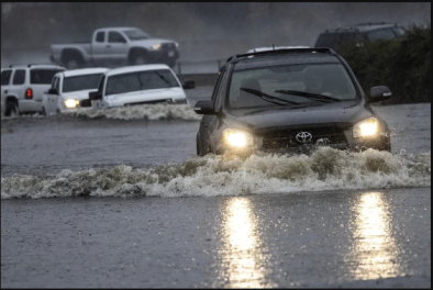
- The West Coast experienced all-time record rainfall, snowfall totals measured in feet, in addition to mud and debris flows.
- Totals of 4-10 inches were reported at many Bay Area locations from San Francisco northward and eastward, extending well into the Central Valley and Sierra Nevada.
- At the downtown station in San Francisco, Sunday was the wettest calendar day for any October by far – and the fourth wettest day for any month – in nearly 173 years of record-keeping.
- At the downtown station in Sacramento, October 24 was the wettest calendar day of any month in 165 years of record-keeping, with 5.44 inches breaking the old record of 5.28 inches set on April 20, 1880. The nearby Sacramento Executive Airport totaled 5.41 inches from early Sunday to early Monday; that’s more than 80 percent of its entire water year total for 2020-21 (6.61 inches) in just a single 24-hour period.
- The Weather Service issued flash flood and debris flow warnings for the Dixie, Caldor, River and Creek fire burn scar areas.
Climate signal #3: Storm intensity increase
Storm intensity is measured by the maximum surface wind speed or the minimum sea level pressure. The lower the pressure in a storm, the more intense it is, and the greater difference in pressure over an area, the stronger the winds.[6] Climate change affects many of the factors that can result in greater storm intensity. It leads to additional latent heat available in warmer air, and it can increase temperature gradients, which increases available potential energy.
Observations consistent with climate signal #3
- As the bomb cyclone approached California, it became the strongest cyclone ever recorded off the coast of the Pacific Northwest with a low pressure of 942.5 hPa.
Climate Signal #4: Atmospheric River Change
It is normal for the western US to receive most of its annual precipitation from atmospheric rivers (ARs), which are long, narrow bands of moisture in the atmosphere that extend from the tropics. But global warming is changing how ARs behave, increasing risks to communities from flooding and landslides and threatening the region's vital water resources and infrastructure. Atmospheric river storms are projected to increase in intensity and duration in California in a warming climate, with the most intense atmospheric river storms becoming more frequent.
Observations consistent with climate signal #4
- This atmospheric river was rated a level 5 out of 5 in the San Francisco Bay area by the Center for Western Weather and Water Extremes in La Jolla, Calif.
Climate signal #5: Weather Whiplash
Human-caused climate change has increased the extremes between periods of drought and periods of high precipitation. The chance of going from major drought to high precipitation events more suddenly than normal is increasing.
Observations consistent with climate signal #5
- Sacramento experienced its wettest day on record on October 24, shortly after experiencing its longest consecutive dry spell on record, all in the midst of an extreme to record-breaking drought.

Rose Andreatta
Rose Andreatta is the director of the Climate Signals project and has over a decade of experience translating scientific information into usable formats for a variety of audiences. Rose earned her Master’s of Public Administration in Environmental Science and Policy at Columbia University and holds a Certificate of Achievement in Weather Forecasting from Pennsylvania State University.


