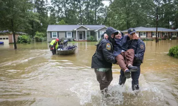
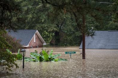
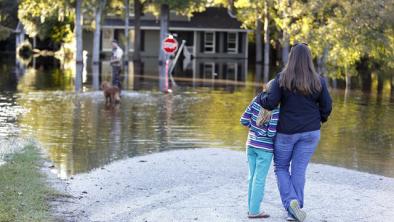
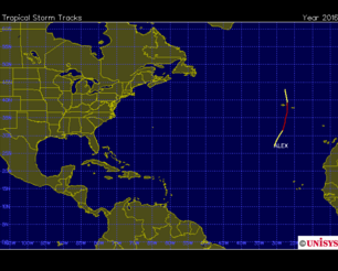
Hurricane Joaquin Remnants Flood South Carolina 2015
Water connected to Hurricane Joaquin converged with another slow-moving storm in the East causing torrential rain and flooding. The severity of the combined storms has links to several climate signals, including more extreme precipitation and warming sea surface temperatures.


Carolinas see catastrophic flooding as climate change-fueled storms converge
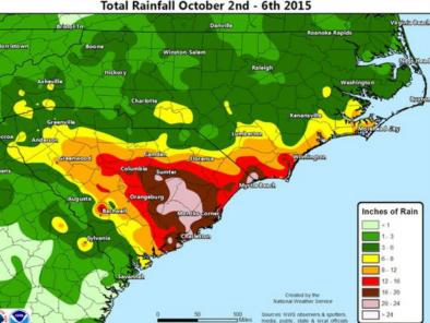
Water connected to Hurricane Joaquin has converged with another slow-moving storm in the East causing torrential rain and flooding. On Saturday, 24-hour rainfall totals in parts of North Carolina, South Carolina and Georgia reached levels likely to occur only once every 100 years, with some regions even experiencing rainfall amounts expected only once every 1000 years.
The severity of the combined storms has many links to climate change. The heaviest rainfall events have become heavier and more frequent across the US, due to an increase in water vapor in the air made possible by warmer temperatures.[1]
Sea surface temperatures in the region where Hurricane Joaquin underwent rapid intensification were the warmest ever recorded. Hurricanes are fueled by warm water, contributing to an increase in the frequency of the most intense hurricanes, and an exponential increase in damage. Virtually every measure of hurricane activity in the Atlantic has increased substantially since the 1970s, due to the combination of human-caused climate change and natural variation.
Hurricane-related precipitation in the Southeast has been increasing
One of the clearest changes in the weather across the US is the increasing frequency and intensity of heavy precipitation. In the past century we have witnessed a 20 percent increase in the amount of precipitation falling in the heaviest downpours. Warmer air can contain more water vapor than cooler air, and studies show the amount of water vapor in the atmosphere has in fact increased over both land and oceans.
Over the period from 1994-2008, extreme precipitation events linked to hurricanes accounted for more than 33 percent of the observed increase in heavy events across the US.[2] The Southeast in particular saw a 40 percent increase in the amount of precipitation falling in the heaviest events, and 100 percent of this increase was linked to hurricane events.
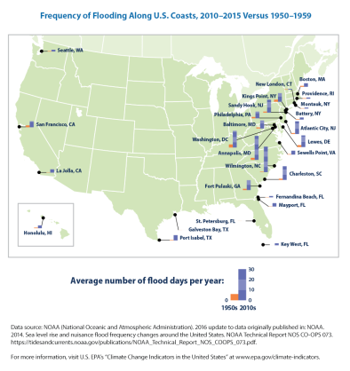
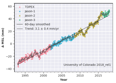
Rising sea levels increase the probability of storm-induced surges and flooding
As the oceans absorb more heat they expand, elevating sea levels. And as glaciers and ice sheets melt, global sea level is rising, giving hurricane storm surge a higher platform from which to run up onto land.
The Atlantic coast is a hotspot of accelerated sea-level rise and flooding.[3],[4] Many East Coast cities have regional rates of sea level rise that are substantially above the global rate due to land subsidence and differences in geography which amplify the local effect of global sea level rise.[5]
Rising sea surface temperatures increase frequency of most severe hurricanes
It is virtually certain that the intensity (or maximum sustained wind speed) of the strongest hurricanes has increased in the North Atlantic since 1970 due tohigher sea surface temperatures where Atlantic hurricanes form.[6]
The size of and rate at which North Atlantic hurricanes intensify have also increased.[7],[8] Climate models predict that the most extreme storms will continue to increase in frequency.

Rose Andreatta
Rose Andreatta is the director of the Climate Signals project and has over a decade of experience translating scientific information into usable formats for a variety of audiences. Rose earned her Master’s of Public Administration in Environmental Science and Policy at Columbia University and holds a Certificate of Achievement in Weather Forecasting from Pennsylvania State University.


