Decade in review: how climate change has made flooding worse
Decade in review: how climate change has made flooding worse
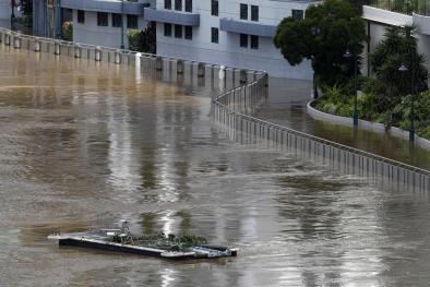
Flooding is one of the primary ways we see climate change at play. It’s deadly, can happen rapidly, and tends to leave vulnerable people with few options. Due to the increase in the frequency of floods and diminishing resources caused by flooding, floods are one of the primary causes of generation trauma through stress, PTSD, and other mental health challenges.
Joy D. Osofsky, LSU Health Sciences Center explains in context of tropical storms, a driver of flooding in coastal communities in the Southeast:Due to climate changes, weather-related extreme events may increase in both frequency and magnitude, and incidents of disasters have been rising steadily, with over 200 million people impacted each year. It is estimated that up to 175 million children and families will be impacted by weather related disasters and, when compared with adults, children often receive insufficient attention. It is important to recognize and plan for special needs of higher risk children and for older adults. Recognizing cultural factors and ecological concerns in preparation, response, and recovery related to both natural and technological disasters will also help support mental health concerns.
To add insult to injury, flood insurance isn’t widely carried by Americans. Only 15 percent of homeowners have flood insurance, leaving repairs and recovery up to the flood survivors. The National Flood Insurance Program is also ill-equipped to deal with the impacts of worsening floods due to climate change.
THIS PAST DECADE:
- 1,042 people in the US died due to flood events from 2010 through now.
- Average annual flood costs in the US from 2010 through 2018 were $4.5 billion dollars. The average annual cost of floods in the United States between 1950 and 2003 is estimated at about $2 billion (Ntelekos et al. 2010). [This does not include hurricane-related flooding.]
- There has been an increase in the frequency of US National Flood Insurance Program (NFIP) claims that parallels the increasing frequency of extreme rainfall and flooding in the United States.
RESOURCES (feel free to use)
- [GRAPHIC] Detectable Human-Caused Increases in Precipitation over North America (1901-2010)
- [REPORTS] Exceedance Probability Analysis for Selected Storm Events
- [BACKGROUND] Runoff and Flood Risk Increase
- [GIF] Climate Change and Flood Risk
- [CHART] Increasing flood claims in a changed climate by Climate Signals
SCIENTIFIC ADVANCES
- Flood gauge data from the 1950s to the 2010s suggests climate change contributed to widespread upward trends in flood magnitude and frequency throughout the Mid-Atlantic US since 1970 (Armstrong et al. 2014).
- Climate change was to blame for three quarters of the coastal floods recorded in the US from 2005 to 2014, mostly high tide floods. That was up from less than half of floods in the 1950s (Strauss et al. 2016). The incidence of daily tidal flooding is accelerating in more than 25 Atlantic and Gulf Coast cities (NCA4).
- Analyzing Hurricane Harvey landfall, scientists show that the volume of rain over land corresponded to the amount of water evaporated from the unusually warm ocean (Trenberth et al. 2018).
- Climate change is elevating flood risk in the US by increasing the frequency of extreme precipitation nationwide and increasing total precipitation in the Mississippi River basin (Knutson and Zeng 2018; Guo et al. 2019; Diffenbaugh et al. 2017)
- Climate change is worsening extreme precipitation and coastal flood events. Studies have shown that climate change increased precipitation, and as a result, flood risk, during Hurricane’s Sandy, Florence, Harvey, Maria, and Irma (Trenberth et al. 2018; Wang et al. 2018; Patricola and Wehner, 2018; Reed et al. 2018; Trenberth et al. 2015). Climate change also increased precipitation during the following events: Winter Storm Goliath, the Boulder flood, the Baton Rouge flood, the Oroville Dam flood, and Mississippi River Basin floods. For more details, see below:
MAJOR [NON-HURRICANE] FLOOD EVENTS OF THE 2010s
2010: TENNESSEE FLOOD
Nashville shattered nearly every rainfall record conceivable the weekend of May 1-2, 2010. According to the National Weather Service, 13.57 inches of rain was measured during a 36-hour period. The combined two-day rainfall total doubled the previous 48-hour rainfall record in Nashville. The weather pattern producing the storms featured a wavy jet stream (Winters and Martin 2014), which may be increasing due to climate change (Mann et al. 2018).
2013: THE BOULDER FLOOD
In 2013, persistent, heavy rains in the Colorado Front Range broke several rainfall records and led to catastrophic flooding. Climate change contributed to the volume of moisture in the atmosphere (Trenberth et al. 2015) and likely increased rainfall by 30 percent (Pall et al. 2017).
2015: WINTER STORM GOLIATH
At the end of December 2015, a huge storm named “Goliath” dumped 9-10 inches of rain in a belt across the central United States, centered just southwest of St. Louis, most of it in a three-day downpour. Later analysis found that human-caused warming increased the likelihood of extreme precipitation in Missouri during this event (Fosu et al. 2018).
2016: THE BATON ROUGE FLOOD
In August 2016, historic floods devastated parts of south Louisiana after a slow-moving system dumped more than 20 inches of rain in parts of East Baton Rouge and nearby parishes in a three-day span. During the 2016 storm, climate change increased the heavy rain experienced in Louisiana by 20 percent (Wang et al. 2016). Heavy precipitation events in Louisiana – such as the August 2016 event that lead to flooding in Baton Rouge – are occurring more frequently due to climate change (Wiel et al. 2017).
2016 & 2018: ELLICOTT CITY FLOODS
Ellicott City saw two 1000 year storms two years apart. Climate change, along with stalled weather patterns and the region's flood-prone geography, contributed to these extreme flooding events. The 2018 flood event was one of several in the Mid-Atlantic impacted by exceptional total precipitation made more likely due to climate change (Winter et al. 2019).
2017: OROVILLE DAM BREACH
In early 2017, a series of weather systems delivered record-breaking heavy precipitation to California. On top of heavy precipitation, warm weather systems dropped rainfall in mountain regions where snow pack was forced to melt back to higher elevations and the resulting melt water joined the mountain run-off from the passing storms. Huang et al. (2018) found that runoff in the watershed supplying the Oroville Dam during the peak precipitation immediately prior to the Dam failure was one-third greater than it otherwise would have been were it not for global warming.
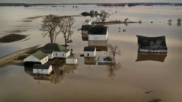
2019: MISSISSIPPI RIVER BASIN TOTAL PRECIPITATION
The Mississippi River Basin experienced record flooding during 2019 that has been likened to the Great Mississippi Flood of 1927. Several river gauges set records for the greatest length of time water levels remained at major flood stage. Climate change has increased the amount of annual precipitation in the Midwest (Knutson and Zeng 2018). The basin also experienced extreme seasonal flooding in 2011 and 2016.
Related Content
