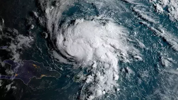
Hurricane Dorian August 2019
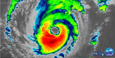
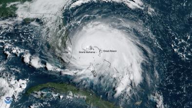
Hurricane Dorian is the fifth Atlantic hurricane in four years to reach Category 5 strength and is one of the strongest hurricanes ever recorded in the Atlantic basin.[1] Dorian made its initial landfall in the Bahamas on Great Abaco Island on August 31 with maximum sustained winds of 185 mph. The storm proceeded to lash the northwest Bahamas for roughly 48 hours causing widespread devastation.[2]
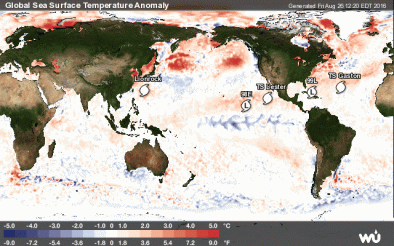
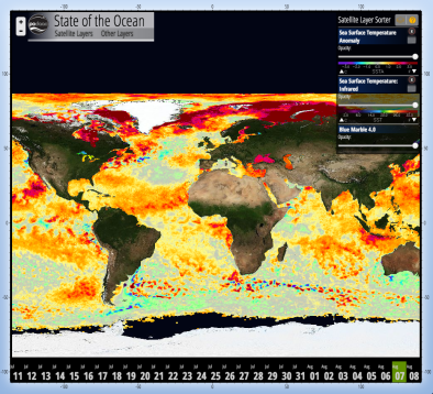
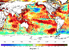
The balance of evidence suggests that global warming is responsible for the increase in global average intensity of the strongest tropical cyclones since the early 1980s, as well as the increase in the proportion of Category 4 and 5 storms. Ocean heat content in the Caribbean is high, and Dorian gained strength passing over very warm sea surface temperatures of 30°C (86°F)[3], giving the storm plenty of energy to fuel intensification.
The science is especially clear when it comes to worsening storm surge and hurricane precipitation—global warming is making hurricanes worse. Sea level rise sets the stage for higher damage due to storm surge, and warmer air holds and dumps more water when it rains.


Climate science at a glance
- Global warming is fueling extreme rainfall, increasing the threat of rain and flooding driven by hurricanes.
-
Sea level rise has significantly extended the reach of hurricane-driven storm surge and coastal flooding.
-
Hurricanes are fueled by available heat, and warmer ocean surfaces are increasing the potential energy available to passing storms. This effectively increases the power ceiling or speed limit for hurricanes.
-
The balance of evidence suggests that global warming is responsible for the increase in global average intensity of the strongest tropical cyclones and the increase in the proportion of Category 4 and 5 storms since the early 1980s.
-
In the span of 14 months from August 2017 to October 2018, the U.S. was struck by five Category 4 or 5 cyclones.[1]
-
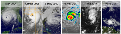
Estimates of global warming's impact on rainfall rates have been calculated for at least six individual hurricanes, including Hurricanes Ivan, Katrina, Sandy, Harvey, Irma, and Maria.
Climate signal breakdown
Climate signal #1: Increased storm surge
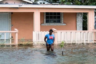
Climate change can lead to increases in storm surge due to rising seas, increasing storm size, and increasing storm wind speeds.[2][3] Historically, storm surge has been the most important impact of tropical cyclones in coastal regions.[2] From 1963 to 2012, storm surge caused 49 percent of hurricane deaths, with rain accounting for 27 percent, according to the National Hurricane Center.[4]
Climate change has already contributed about 8 inches (0.19 meters) to global sea level rise,[5] and this has dramatically amplified the impact of cyclones by increasing baseline elevations for waves and storm surge.[5][6][7][8] A small vertical increase in sea level can translate into a very large increase in horizontal reach by storm surge depending upon local topography.
Observations consistent with climate signal #1
-
Hurricane Dorian brought a 23-foot-high wall of water to parts of the Bahamas.
-
Dorian's storm surge could flood coastal communities in Florida, Georgia, and South Carolina with up to 8 feet of water, according to the National Hurricane Center.
Climate signal #2: Extreme precipitation
One of the clearest changes in weather globally is the increasing frequency of heavy rain. As the global average temperature increases, so too does the ability of the atmosphere to hold and dump more water when it rains.[9] Atmospheric water vapor has been increasing.[10][11] And the observed increases have been studied and formally attributed to global warming.[5][12][13]
Global warming is increasing rainfall rates during tropical cyclones.[2] Over the period from 1994-2008, extreme precipitation events linked to hurricanes accounted for more than 33 percent of the observed increase in heavy events across the US.[14] The Southeast in particular saw a 40 percent increase in the amount of precipitation falling in the heaviest events, and 100 percent of this increase is linked to hurricane events.[14]
Storms reach out and gather water vapor over regions that are 10-25 times as large as the precipitation area, thus multiplying the effect of increased atmospheric moisture.[9] As water vapor condenses to form clouds and rain, the conversion releases heat that adds buoyancy to the air and further fuels the storm.[15] This increases the gathering of moisture into storm clouds and further intensifies precipitation.[9]
The increase in extreme precipitation has increased the threat of flooding, dramatically illustrated by the 1,000-year rainfall dropped by Hurricanes Matthew, Harvey, and Florence. Inland cities near large rivers in the US now experience more flooding, and this shift is consistent with climate change.
Observations consistent with climate signal #2
- Dorian made landfall on Saint Thomas in the US Virgin Islands as a Category 1 hurricane bringing up to 5.7 inches of rain.[16]
Climate signal #3: Intense Atlantic hurricane frequency increase
The balance of evidence suggests that global warming is responsible for the increase in global average intensity of the strongest tropical cyclones since the early 1980s, as well as the increase in the proportion of Category 4 and 5 storms.[17] The Fourth National Climate Assessment states, “Increases in greenhouse gases and decreases in air pollution have contributed to increases in Atlantic hurricane activity [frequency and intensity] since 1970.”[18] The close correlation between observed trends in recent sea surface temperatures and observed trends in the intensity of tropical cyclones reflects the link between warming ocean temperatures and stronger storms.[19][20][21]
The frequency of the rapid intensification of hurricanes before making landfall in the US is increasing.[22] In October 2018, Hurricane Michael made landfall as a Category 5 storm in the Florida panhandle, turning rural areas of the state into an apocalyptic scene. The year before that, in 2017, Hurricane Irma made landfall as a Category 4 storm in the Florida Keys. The state remains in an ongoing stage of recovery due to back-to-back hurricanes.
There has been a global increase in the observed intensity of the strongest storms over recent decades.[19][23] The fingerprint of global warming in the intensity of tropical cyclones has been identified in one ocean basin: the Northwest Pacific.[24] In 2015, accumulated cyclone energy (ACE) in the western North Pacific was extreme, and human-caused climate change "largely increas[ed] the odds of the occurrence of this event."[24]
Observations consistent with climate signal #3
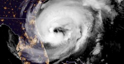
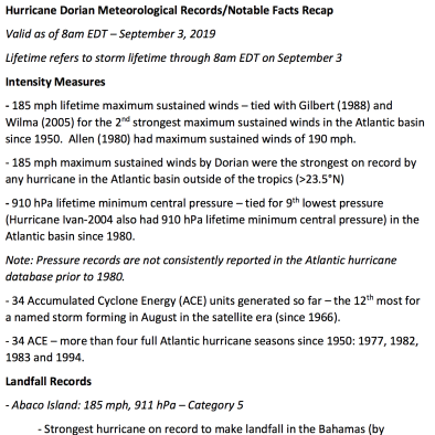
- Hurricane Dorian's peak sustained winds rank as the strongest so far north in the Atlantic Ocean east of Florida on record. Its pressure, which bottomed out at 910 millibars, is significantly lower than Hurricane Andrew’s when it made landfall in South Florida in 1992 (the lower the pressure, the stronger the storm).[25]
- The unusual strength of Dorian and the rate at which it developed is consistent with the expectation of more intense hurricanes in a warming world. In a space of just nine hours on Sunday, its peak winds increased from about 150 mph (130 knots) to 185 mph (160 knots) — a rate of intensification never before observed for a storm this strong.[26]
- Sea surface temperatures on August 27 were a very warm 30°C (86°F)[27], and the total heat content of the ocean was high, giving the storm plenty of heat energy to fuel intensification.
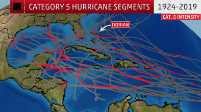
- Dorian's intensification into a Category 5 marked the fourth year in a row the Atlantic basin has had at least one hurricane reach that strength. That's the most consecutive years on record with at least one Category 5 in the Atlantic, topping a three-year stretch from 2003 to 2005.[28]
Climate signal #4: Atlantic hurricane steering change
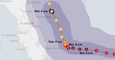
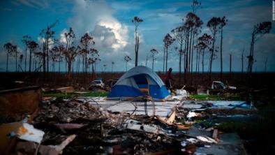
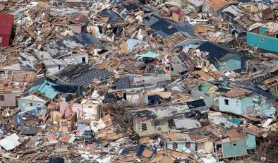
The devastation in the Bahamas was so high in part because Dorian stalled over the country for roughly 48 hours[29], causing absolute devastation on Abaco and Grand Bahama Islands, two locations where the eye of the storm made landfall. Grand Bahama Island remained in the eyewall of a major Category 4 or 5 storm for 24 hours or more.[30]
Global warming affects large scale weather patterns and the weather systems, such as hurricanes, embedded within. Research has documented several recent changes in hurricane steering such as increased stalling and shifts toward higher latitudes.
Observations consistent with climate signal #4
Related Content