Typhoon Meranti 2016
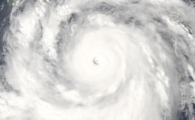
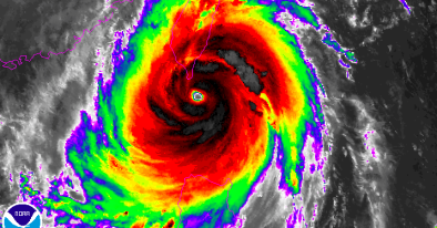
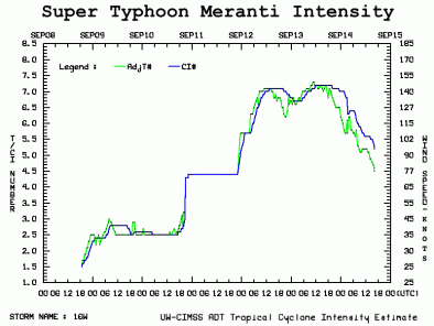
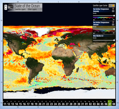
Super Typhoon Meranti rapidly intensified into a Category 5 storm with maximum sustained winds up to 190 mph, making it the strongest cyclone of 2016 and the strongest since 2013's Super Typhoon Haiyan. The fingerprint of global warming has been found in the extreme energy recently observed in tropical cyclones in the northwest Pacific ocean.
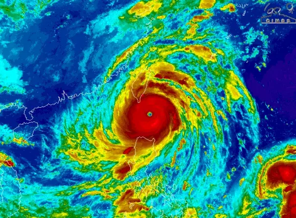
In its march towards southeastern Taiwan, Meranti’s top winds jumped from 85 mph to 180 mph in the 24 hours ending Monday at 11:00 am EDT, more than doubling the criteria for rapid intensification. The rapid intensification of Meranti was driven by favorable climate conditions, including passage over unusually warm seas.
There is a documented increase in the intensity of the strongest storms in several ocean basins in recent decades, including the Pacific Northwest as well as a documented trend towards more rapid intensification. These increases are linked to warming seas that offer more energy to passing storms.
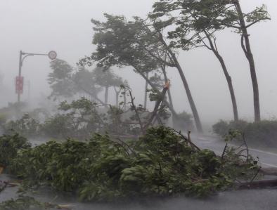
Extreme rainfall is also a major concern in Taiwan and eastern China, with over 12 inches of rain forecast for southeastern Taiwan. Ocean warming increases evaporation driving extreme rainfall and the intensity of tropical weather systems. At the same time, a warmer atmosphere is able to hold and dump more water, a change that has already led to a significant increase in extreme precipitation and flooding risk.
Along coastlines, sea level rise due to global warming increases the risk of coastal flooding by boosting the platform from which typhoons inundate coastal areas.


Typhoon Meranti's rapid intensification consistent with observation that cyclones are intensifying faster
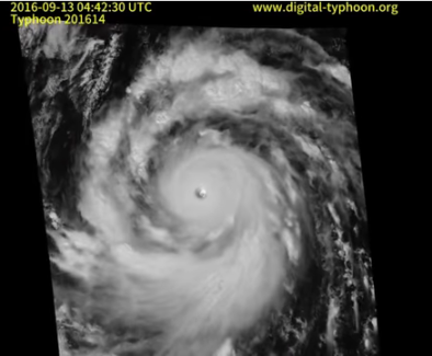
Super Typhoon Meranti, the strongest storm of 2016 and the strongest since 2013's Super Typhoon Haiyan, achieved maximum sustained wind speeds of 190 mph on Tuesday, September 13.[1] The fingerprint of global warming has been found in the extreme energy recently observed in tropical cyclones in the northwest Pacific ocean.[2] Meranti peaked at the equivalent of a Category 6 hurricane, if the Saffir-Simpson Hurricane Scale extended beyond five.[20] The typhoon recorded 185 mph winds for 18 straight hours, a feat only matched by two other typhoons since 1970.[3]
 Meranti’s top winds jumped from 40 to 85 mph in the 24 hours leading up to 8:00 am EDT on Sunday, September 11,[4] and from 85 mph to 180 mph in the 24 hours ending Monday at 11:00 am EDT.[5] The 95 mph increase in winds during that time is more than double the rapid intensification criteria.[5] For a storm to be classified as "rapidly intensifying" its maximum sustained wind speeds must increase 35 mph (30 knots) in 24 hours, according to the National Hurricane Center's definition for rapid intensification.
The rapid intensification of Typhoon Meranti is consistent with the observed trend indicating that tropical cyclones are intensifying faster.[6][7]
Warm ocean temperatures and low wind shear were behind the storm's rapid strengthening. Before making landfall in Taiwan, Typhoon Meranti will be traveling through an environment with "very warm ocean water which is favorable for holding on to [its] strength," said AccuWeather meteorologist, Adam Douty.[8]
A September 2016 study finds that the intensity of landfalling storms in the Pacific northwest is increasing due to an increase in the rate at which storms intensify, which in turn is linked to increasing sea surface temperatures.[9] Typhoons that strike East and Southeast Asia have intensified by 12–15%, with the proportion of storms of categories 4 and 5 having doubled or even tripled.[9]
Warming seas are increasing the limits for powerful storms
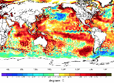
 Tropical cyclones are fueled by available heat. During Typhoon Meranti's intensification, sea surface temperatures were 1.7°F - 3.6°F above the average from 1985 to 2001, offering more energy to the storm.[10]
By increasing the potential energy available to passing storms, warming seas are effectively increasing the power ceiling or speed limit for these cyclones.[11] However, other factors, such as wind shear and the global pattern of regional sea surface temperatures, also play controlling roles. And the balance of these factors is not fully known.[12]
As seas warm and offer more heat energy, there has also been a global increase in the observed intensity of the strongest storms. The increase is well-documented and is consistent with models projecting the future climate, but scientists are still working to better understand the relation between these two trends.[11]
Fewer but stronger storms would likely lead to an increase in overall damages
Damage incurred by tropical cyclones is overwhelmingly and disproportionately incurred by the most powerful storms, indicating that overall damage will increase as the climate warms.
Cyclone wind damage increases geometrically with an increase in speed.[13] A decrease in frequency would not be expected to offset the increase in damages incurred by increasing intensity. Moreover, damage escalates exponentially when storm strength crosses over the thresholds beyond which threatened infrastructure collapses.
It's the high end events that are the most destructive historically....More than half the damage that's been done in the United States by storms dating back to the middle of the 19th century has been done essentially by just eight events. So it really is the rare events, the Katrinas, the Sandys, that do the overwhelming amount of damage. Your average run-of-the-mill hurricane will do some damage and be memorable in the local place that if affects, but it doesn't really amount to a hill of beans compared to what the big storms do.
Dr. Kerry Emanuel [14]
Higher storm surge
The most important impact of tropical cyclones in coastal regions is often storm surge.[11] Increases in storm surge can be driven by both sea level rise and increasing cyclone wind speeds.[11]
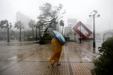
Fortunately for Taiwan, Meranti's center of circulation tracked south of the island, meaning the real concern for coastal flooding will come the night of Wednesday, September 14, as Meranti approaches China's coast as a Super Typhoon, with winds equivalent to a Category 4 storm.[1]
Climate change has already contributed about 8 inches (0.19 meters) to global sea level rise,[15] and this has already dramatically amplified the impact of cyclones by increasing baseline elevations for waves and storm surge.[16]
Small vertical increases in sea level can translate into large increases in horizontal reach by storm surge depending upon local topography. For example, sea level rise extended the reach of Hurricane Sandy by 27 square miles, affecting 83,000 additional individuals living in New Jersey and New York City.[17]

More extreme rainfall
Climate change is also dramatically increasing the rainfall of tropical cyclones.[18] And an increase in rainfall rates is one of the more confident predictions of the effects of future climate change on tropical cyclones.[11]
As Meranti brushed by the southern end of Taiwan, the storm dumped up to 30 inches (760 millimeters) of rain in some locations.
Rainfall of more than 15.75 inches (400 millimeters) was reported in Zhejiang province as Meranti slogged inland.[19]
Related Content