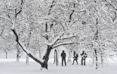
Winter Storm Risk Increase
Climate change makes cold events less likely on average, but extreme, even record-breaking winter weather still happens in a warming world. In some instances, climate change may even be exacerbating extreme cold and snow events. Warmer air due to climate change creates conditions more favorable for extreme precipitation, including snowstorms. In addition, a growing body of evidence shows that decades of warming and rapid heating of the Arctic is contributing to changes in mid-latitude climate and weather, as well as the occurrence of extreme events. In the US, rapid Arctic warming is frequently associated with disruptive winter weather, and there's evidence climate change may be destabilizing the polar vortex, driving arctic blasts south.[1]
Read More
Climate science at a glance
- One of the clearest changes in the weather across the US due to climate change is the increasing frequency and intensity of heavy precipitation.[1]
- A warmer atmosphere holds more water, and storms supplied by climate change with increasing moisture are widely observed to produce heavier rain and snow.
- A growing body of research links rapid Arctic warming to jet stream and stratospheric polar vortex weakening that can lead to outbreaks of Arctic air in the US.
Background information
How is climate change linked to more intense snowstorms?
Warmer air holds more water because the water vapor molecules it contains are moving at a higher average speed than those in colder air making them less likely to condense back to liquid. According to the Clausius–Clapeyron equation, for each 1°C of warming, saturated air contains 7 percent more water vapor, which may precipitate out if conditions are right.[2] The average moisture content of the atmosphere has increased by about 4 percent since the 1970s, as expected from the Clausius–Clapeyron law.[3]
Storms reach out and gather water vapor over regions that are 10-25 times as large as the precipitation area, thus multiplying the effect of increased atmospheric moisture.[4] As water vapor condenses to form clouds, rain, or snow, the conversion releases heat that add buoyancy to the air and further fuels the storm.[5] This increases the gathering of moisture into storm clouds and further intensifies rain and snowfall.[4]
How is warming in the Arctic linked to extreme winter weather in the US?
Rapid Arctic change (known as Arctic amplification) is contributing to changes in mid-latitude climate and weather, as well as the occurrence of extreme events. But how significant the contribution is and what mechanisms are responsible are less well understood. Scientists have identified many physical processes or mechanisms that may play important roles in linking Arctic change to mid-latitude climate and weather.
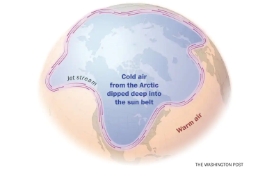
One of the ways that Arctic amplification could be affecting the mid-latitudes is by weakening the jet stream. The jet stream is a band of fast-flowing air high up in the atmosphere that drives weather in mid-latitude regions such as the United States. The strength of the jet stream depends on the temperature difference between warmer air near the tropics and cooler air near the Arctic. Scientists have theorized that due to rapid warming in the Arctic, the temperature difference between high and low latitudes is declining, which leads to a weaker and wavier jet stream. When the jet stream is wavy, it contorts sharply towards the poles with ridges of high pressure and dips to the equator with troughs of low pressure. This extreme configuration increases the risk of the jet stream getting stuck in place, which leads to longer periods of extreme weather. The result is that certain areas and seasons are getting a lot more cold and snowy weather, while in other areas, extreme winter weather is less common.
US winter storm trends and climate change
- NOAA scientists, examining 120 years of data, found that there were twice as many extreme regional snowstorms in the US between 1961 and 2010 compared to 1900 to 1960.
- According to the US Fourth National Climate Assessment, "Heavy precipitation events [defined as the heaviest 1 percent of all daily events] in most parts of the United States have increased in both intensity and frequency since 1901."[6]
- From 1958 to 2016, the amount of precipitation falling in very heavy events (the top 1 percent of all daily precipitation events) increased by 55 percent in the Northeast, 27 percent in the Southeast, 42 percent in the Midwest, 29 percent in the Northern Great Plains, 12 percent in the Southern Great Plains, 10 percent in the Southwest, and 9 percent in the Northwest.[6]
- In the past century, the US has witnessed a 20 percent increase in the amount of precipitation falling during the heaviest storms.[7]
- During mid-winter to late-winter of recent decades, when the Arctic warming trend is greatest and extends into the upper troposphere and lower stratosphere, severe winter weather—including both cold spells and heavy snows—became more frequent in the eastern United States.[8]
US studies attribute increases in winter storm risk to climate change
- (Fosu et al. 2018): Data shows a likely effect of anthropogenic warming on the December 2015 extreme precipitation event in Missouri.[9]
- (Trenberth et al. 2015): During "Snowmaggedon" in February 2010, high sea surface temperatures linked to human caused global warming fed moisture into the storm, helping it to intensify and causing heavy precipitation.[10]
- (Knutson et al. 2014): Seasonal and annual mean precipitation extremes occurring during 2013 in north-central and eastern US regions were attributable to anthropogenic and natural forcings combined.[11]
Global winter storm trends and climate change
- Evidence suggests that Arctic amplification of global warming remotely affects mid-latitude regions such as the United States by promoting a weaker, wavier atmospheric circulation conducive to extreme weather.[12][13]
- Multiple observational studies suggest that Arctic amplification has caused concurrent changes in the Arctic and Northern Hemisphere large-scale circulation since the 1990s.[14][15][16]
- The 5th Assessment Report of the Intergovernmental Panel on Climate Change states: It is likely that since about 1950 the number of heavy precipitation events over land has increased in more regions than it has decreased. Confidence is highest for North America and Europe where there have been likely increases in either the frequency or intensity of heavy precipitation with some seasonal and regional variations. It is very likely that there have been trends towards heavier precipitation events in central North America.[17]
- Global analyses show that specific humidity, which measures the amount of water vapor in the atmosphere, has increased over both the land and the oceans.[17]
- During the past 25 years, satellites have measured a 4 percent rise in atmospheric water vapor that is in line with the basic physics of a warming world and computer modeling of our current climate.[18][19]
Global studies attribute increases in winter storm risk to climate change
- (Diffenbaugh et al. 2017): An April 2017 study found that, from 1961 to 2010, global warming increased the likelihood of occurrence of the wettest five-day periods on record in 41 percent of the observed areas of the world.[20]
- (Fischer and Knutti 2015): About 18 percent of the "moderate" (i.e. 1-in-3 year) daily precipitation extremes over land are attributable to warming, while a much larger share of very extreme events is attributed to warming.[21]
- (Fischer and Knutti 2014): There is a distinct intensification of heavy precipitation events and hot extremes at local scales. Observed local trends across the globe for the period 1960–2010 are clearly different to what would be expected from internal variability.[22]
- (Zhang et al. 2013): Anthropogenic forcings in extreme precipitation are detectable in observations in the northern hemisphere. The authors estimate that human influence has intensified annual maximum 1 day precipitation in sampled Northern Hemisphere locations by 3.3 percent on average.[23]
- (Min et al. 2011): Human-induced increases in greenhouse gases have contributed to the observed intensification of heavy precipitation events found over approximately two-thirds of data-covered parts of Northern Hemisphere land areas.[24]
- (Min et al. 2008): The authors decisively detects anthropogenic signals in extreme precipitation changes in global, hemispheric, and zonal band areas.[25]